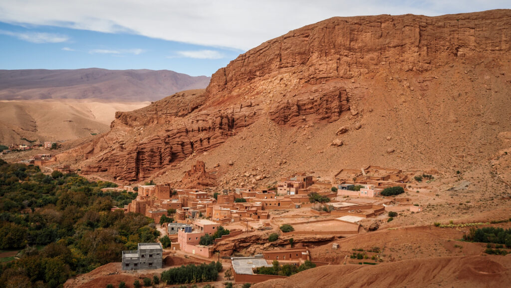
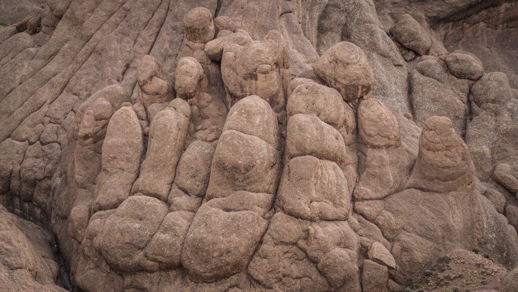
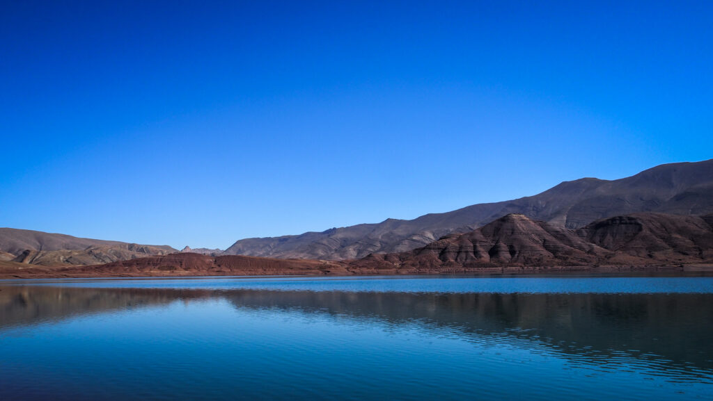
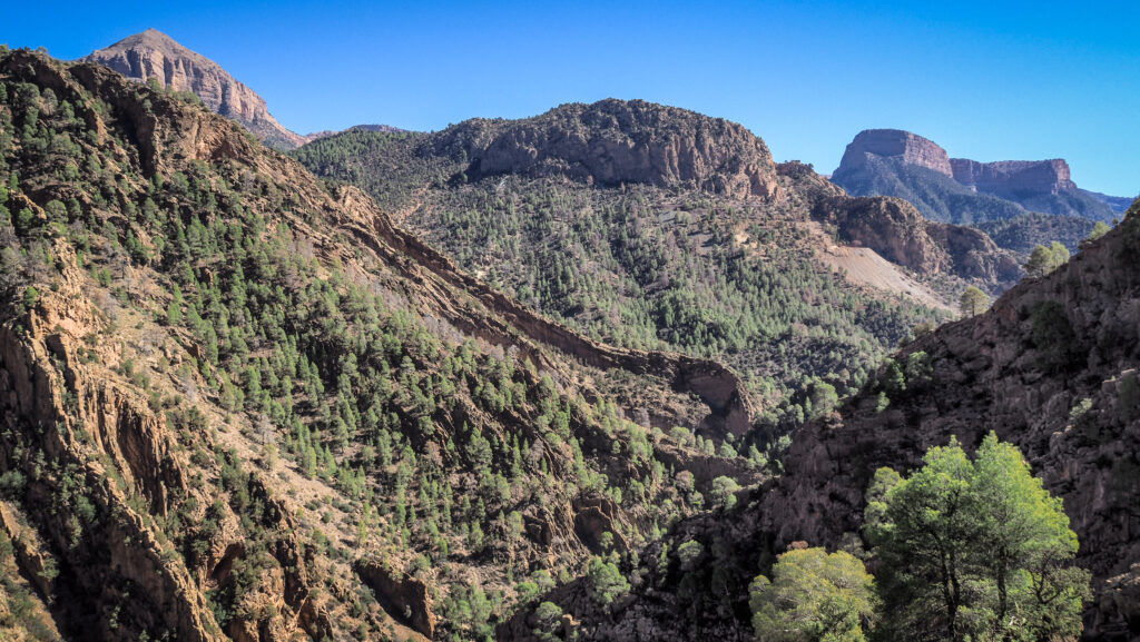
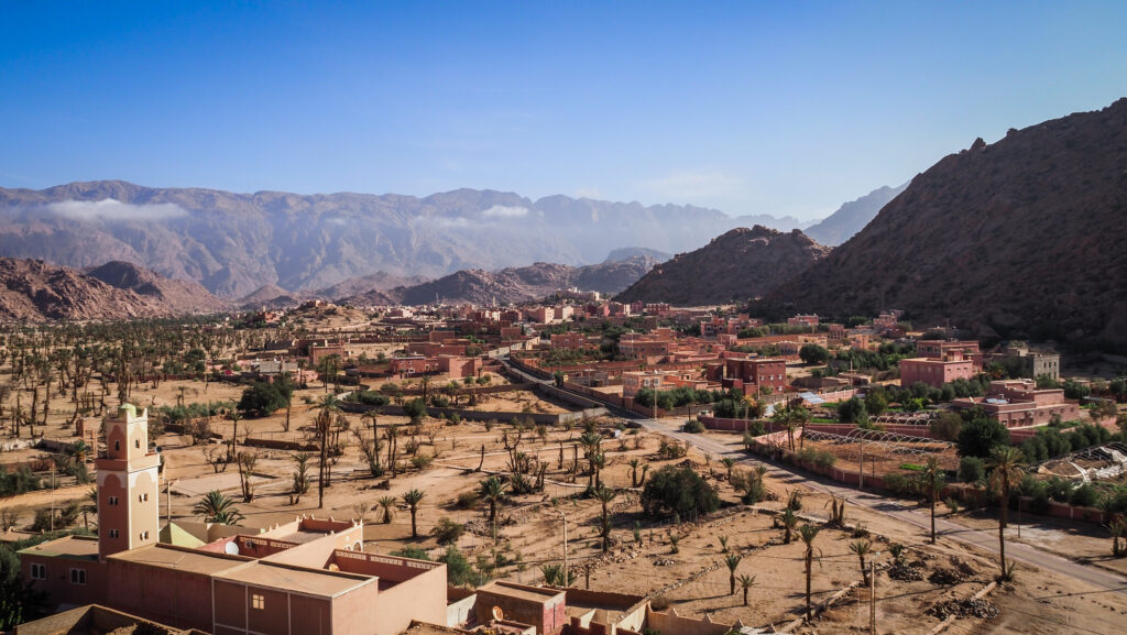
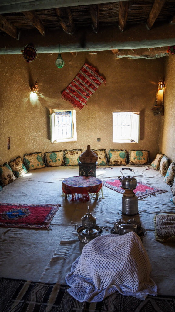
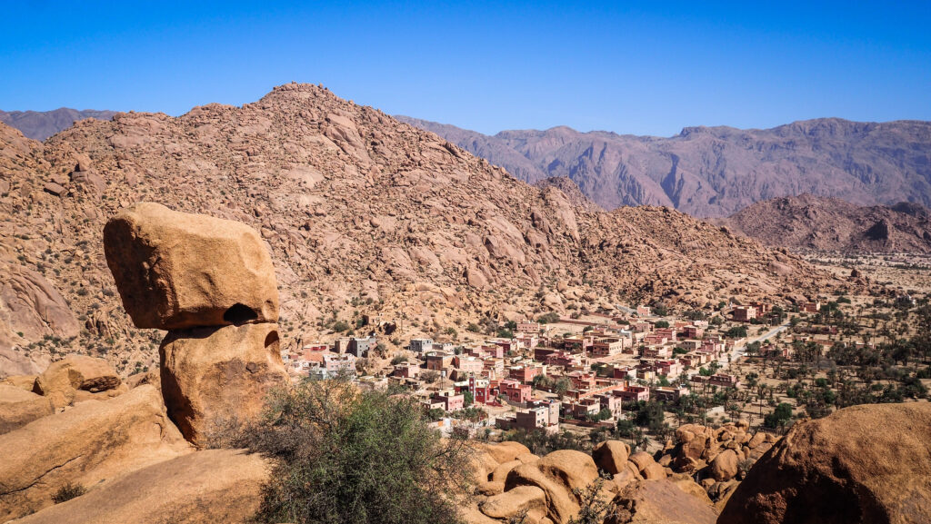
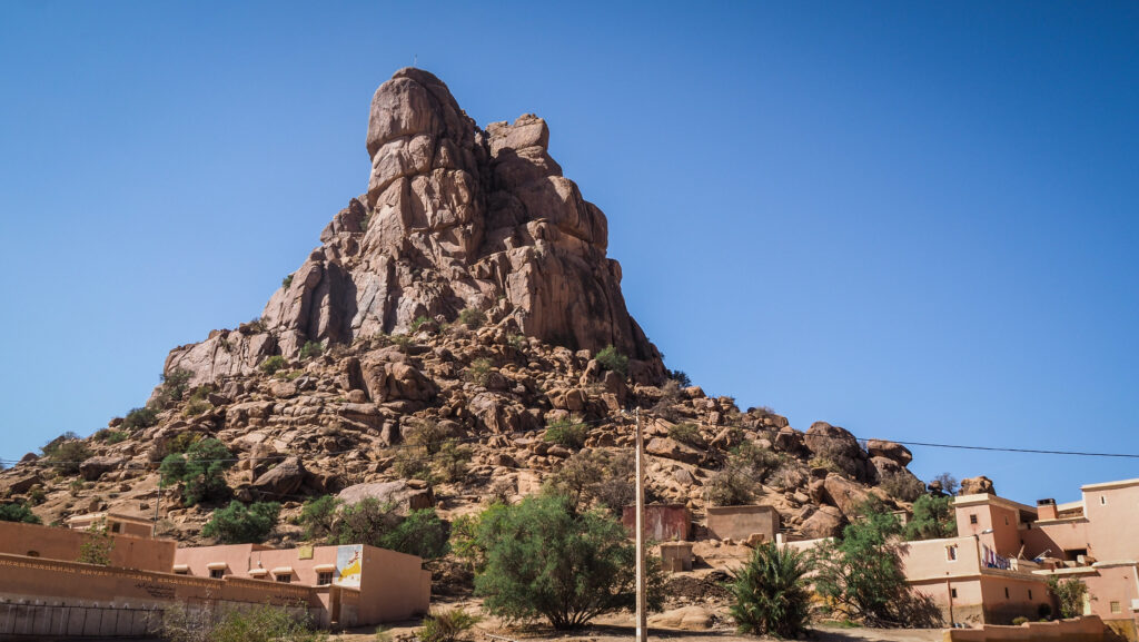
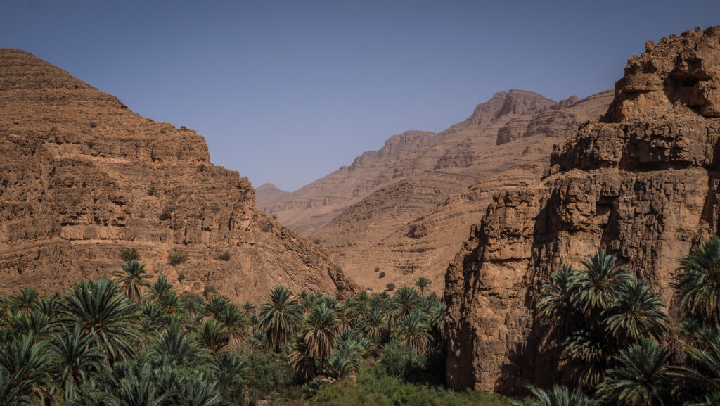
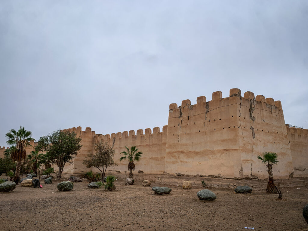
The Monkey Fingers is a scenic trek through the Dadès Gorge region, specifically in an area known for its unique rock formations that resemble the fingers of a monkey’s hand. These formations are located near the village of Tamellalt in the High Atlas Mountains.
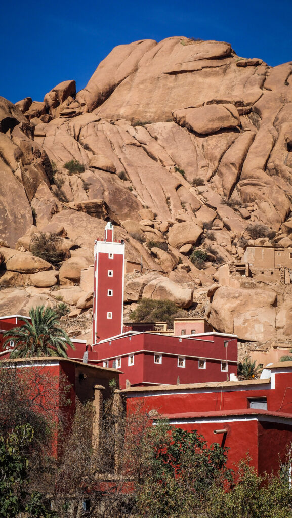
The hike offers an exciting combination of dramatic landscapes, towering red rock canyons, and narrow gorges, making it a popular destination for adventurous travellers and nature lovers. Hikers can explore therock formations and the surrounding valleys, discovering small Berber villages, and beautiful viewpoints over the gorge. The area is also dotted with kasbahs (traditional mud-brick fortresses), adding a cultural dimension to the experience.
How to get there?
From Marrakech or Ouarzazate
You can start your journey from Marrakech, which is about 300 km from the Dadès Valley. Most people combine a trip to the Dadès Valley with a tour of the Sahara Desert.
Ouarzazate is closer to the Dadès Valley (about 140 km) and is often a stopover point. Many travellers visit Ouarzazate for its proximity to both the Dadès and Todra Gorges.
By Car
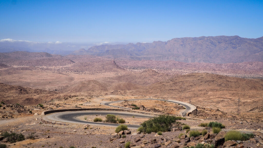
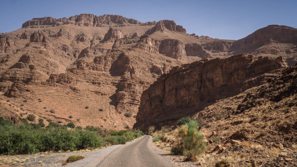
Renting a car is the most flexible way to travel. From Marrakech, take the N9 road towards Ouarzazate, passing through the scenic Tizi n’Tichka Pass in the Atlas Mountains. From Ouarzazate, continue on the N10 road towards Boumalne Dadès (the town nearest to the Monkey Fingers).
From Boumalne Dadès, you’ll drive a further 25 km into the Dadès Gorge until you reach the village of Tamellalt, the starting point for the Monkey Fingers hike.
Panorama of the village
By Bus
You can take a bus from Marrakech or Ouarzazate to Boumalne Dadès. The journey from Marrakech takes about 7–8 hours, while from Ouarzazate, it’s roughly 2–3 hours. Popular operators include CTM or Supratours.
Once you arrive in Boumalne Dadès, you can hire a taxi or arrange for local transport to Tamellalt and the entrance to the Monkey Fingers trail.
By Tour
Many tour operators offer guided trips to the Dadès Valley from Marrakech or Ouarzazate, often as part of multi-day desert tours that include the Sahara, Ait Benhaddou, and Todra Gorge. These tours will handle all transportation and logistics, making it a more convenient but less flexible option if you want to explore at your own pace.
The best time to visit
Plan your trip in spring or autumn for the best weather conditions. While winter is generally mild, it can get quite cold at night and in the mornings, with temperatures occasionally dropping close to freezing, especially at higher elevations. Summer can be hot, but temperatures are milder in the mountains.
You should always have some warmer layers, regardless of the season. In the end, it’s mountains there!
Where to stay?
If you decide to spend a night in the area, you won’t have problems finding a place to stay. A good choice might be Monkey Fingers House by Fatima Mellal.
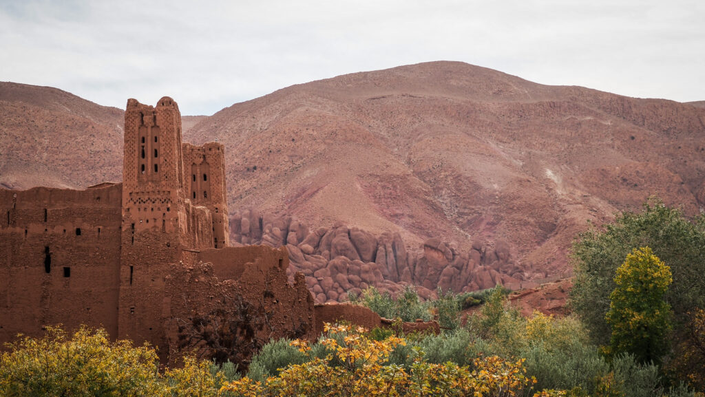
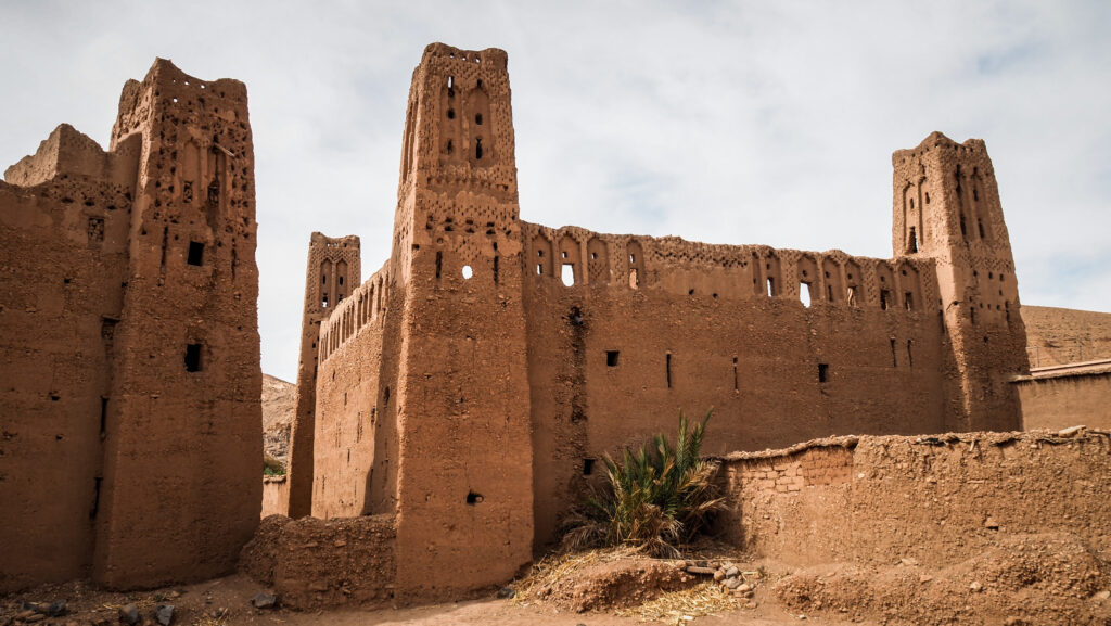
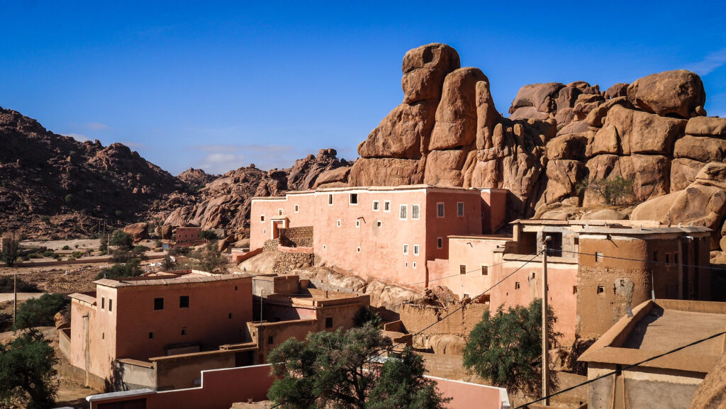
Kasbah
How long is the hike?
The distance of the loop is about 8 kilometers and you should plan at least 3 hours to walk it comfortably.
Do you need a guide?
You may want to hire a local guide from the village to lead the hike, especially if you’re unfamiliar with this kind of activity. A guide can also help you up in case you choose to follow the trail that goes to the top of the rocks and involves some scrambling. Ask about one at your accommodation.
For hiking enthusiasts, there is absolutely no need to hire a guide. Just get yourself a good offline map such as Mapy.CZ to check your position on the trail in case of doubts.
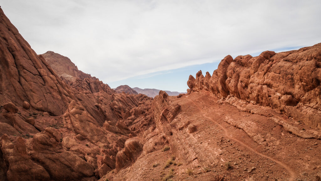
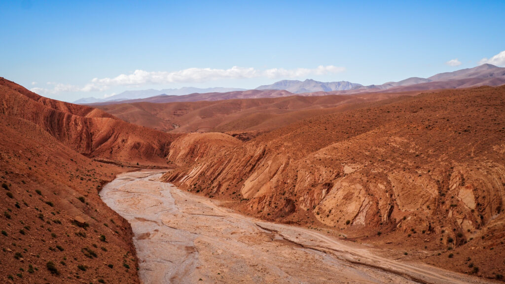
The hike around Monkey Fingers
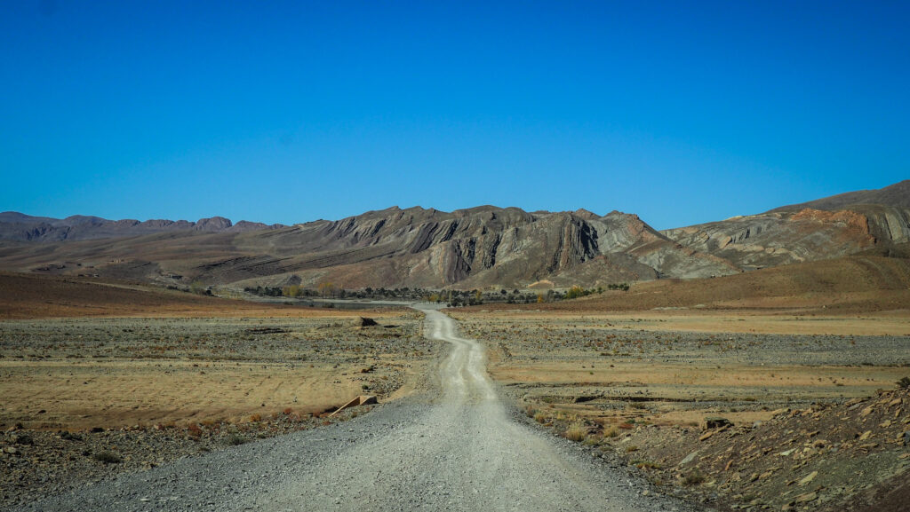
I parked the car at the roadside near Imzzoudar and walked through Ait Arbi village. Very atmospheric place but it looked like abandoned, without any inhabitants visible around it. I was following the trail anti-clockwise in the direction of the rocks.
Remains of Kasbah in the villageThe first interesting rock formations
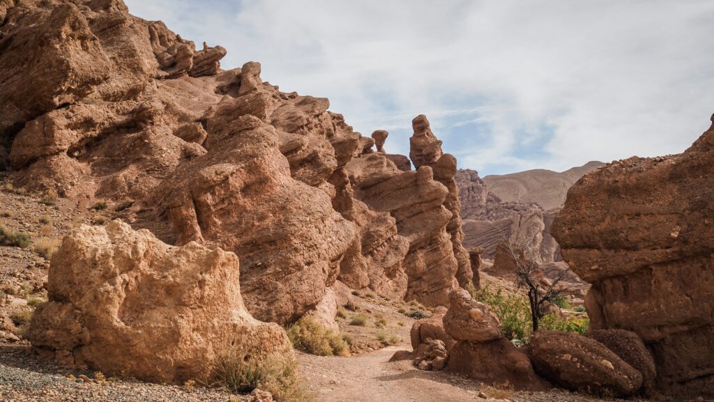
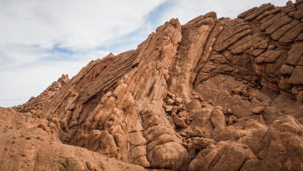
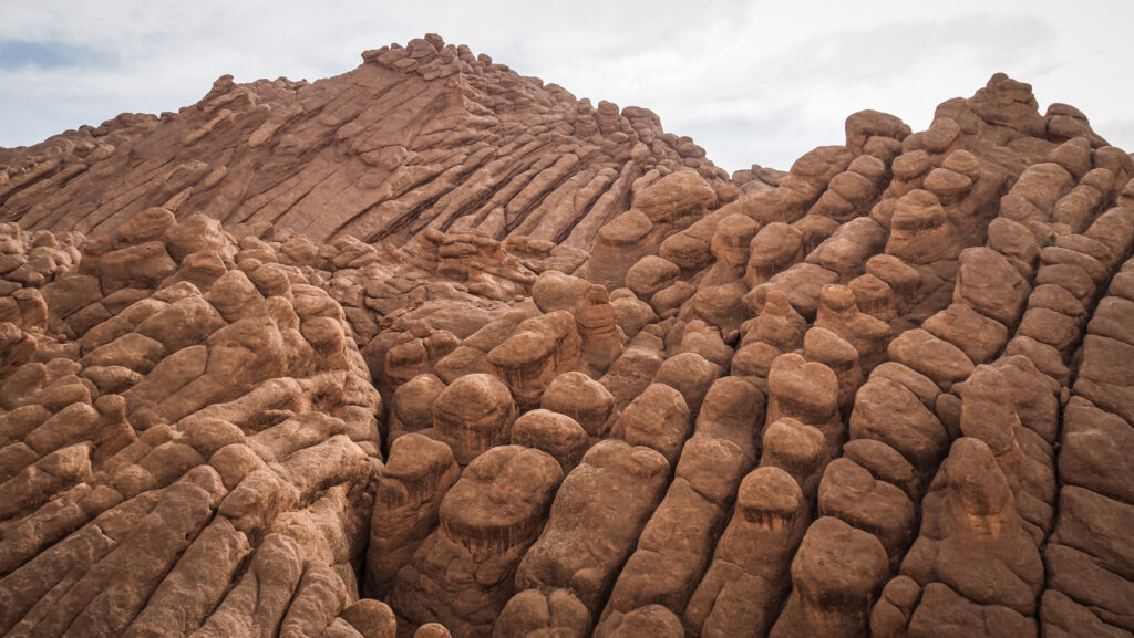
Once you get to the bottom of the rocks, you will need to make a decision. There are 3 routes to choose from. The first leads along the base of the rocks, with interesting formations on your right side. The second one goes in the middle of the gorge, while the third one climbs up the rocks for better panoramic views. Eventually, they all merge.
I chose the trail that goes higher and includes climbing on top of the rock mass. There were sections where I had to think where to put my feet but if you are reasonably fit and you don’t mind pulling yourself up, then it will be alright. The views from up there were simply incredible!
The upper path on Monkey FingersMonkey FingersMonkey FingersMonkey Fingers
At some point, I met a group walking in the opposite direction with a guide and he gave me some advice on how to descend to rejoin the track going at the base of the rocks. BTW, he was doing the track in flip flops. People never stop amusing me.
After merging with another track, the rest was a piece of cake. At the crossroads of trails, I turned left and then left again into a beautiful valley with a dried riverbed. Soon, I returned to the car. Very glad and satisfied that I decided to go for that hike! Well worth it.
Dried riverbed in the valley
Sidi Boubker
A bit further down the road towards Boumalne Dades in another gorge – Sidi Boubker. You can park the car near Hotel Atlas Gorge Dades and walk down. On my visit in November, there was a lot of water in the gorge so I was not able to explore it deeper.
Imilchil is a small village located in the Atlas Mountains of Morocco, specifically in the High Atlas range. It is best known for its remote beauty, the annual Imilchil Marriage Festival and two beautiful lakes nearby: Tislit and Isli. The town sits at a high altitude, around 2,200 meters (7,200 feet) above sea level, making it a cold, rugged, and mountainous region. Winters can be harsh with snow, while summers are more temperate.
The village is most famous for its marriage festival, an annual event held in September. Historically, it was a time when young men and women from Berber tribes in the region could meet and choose partners, with their families’ approval. Today, visitors can witness traditional Berber customs, music and dancing. It’s a great opportunity to immerse yourself in local culture!
The festival has its roots in the story of two star-crossed lovers from opposing tribes, Isli and Tislit, who were forbidden from marrying. Their grief was so deep that they cried themselves to death, forming the two lakes near the village. As a result, the festival was established to celebrate love and marriage.
How to get there?
From Major Cities
Marrakech to Imilchil (around 300 km / 7-8 hours):
The most common route is by car or bus. You would first drive towards Beni Mellal (about 3-4 hours from Marrakech) and then continue towards Ait M’hamed and Tilmi before arriving in Imilchil. This route will take you through beautiful valleys and mountain roads.
Alternatively, you can take a bus or shared taxi from Marrakech to Azilal, and from there, you may need to arrange private transport to Imilchil.
Fes to Imilchil (around 270 km / 6-7 hours):
You can travel via Midelt, a town located on the national road between Fes and Imilchil. From Midelt, you drive through the High Atlas Mountains via Ait Hani to reach Imilchil. The road is scenic but winding and steep, so be prepared for a rugged but rewarding journey.
Shared taxis and buses can take you as far as Midelt or Rich, but a private taxi or car hire is needed for the final leg.
Ouarzazate to Imilchil (around 240 km / 6-7 hours):
From Ouarzazate, you would drive towards the town of Skoura and continue via Boumalne Dades and Tamtatoucht before reaching Imilchil. This route involves crossing mountain passes and offers beautiful views of gorges and valleys.
Some buses may travel this route to nearby towns, but again, private transportation is often required to complete the trip.
Transportation Options
By Car
Renting a car is the most flexible and comfortable option. It allows you to stop along the way to enjoy the scenery and small Berber villages. The roads are generally good but can be narrow and winding, especially as you climb into the mountains.
By Bus
CTM and other bus companies offer services to nearby towns such as Beni Mellal, Midelt, or Rich. From these points, you will likely need to hire a private taxi or take a shared taxi (called “grand taxis”) to reach Imilchil. Bus travel is the cheapest option, but it can be slower and less flexible than driving yourself.
By Shared Taxi (Grand Taxi)
Shared taxis are common in Morocco and can be a more affordable alternative to renting a private car. They usually operate between major towns like Azilal, Beni Mellal, Midelt, and smaller villages. These taxis can be crowded and may not always offer the most comfortable ride, but they are a good way to travel if you don’t want to drive.
The best time to visit
The best time to visit Imilchil and the surrounding lakes Tislit and Isli is typically from late spring to early autumn, especially from May to September.
May to September offers the most comfortable weather, as temperatures are mild, and the risk of snow in the High Atlas Mountains is lower.
Summer (June to August) can be ideal because of warmer temperatures in the region, though it remains cooler compared to lower elevations in Morocco due to the altitude.
Autumn (September to October) is also pleasant, especially during the famous Imilchil Marriage Festival in late September.
Winters (November to March) are very cold in Imilchil, with heavy snowfall and harsh conditions, making travel and outdoor activities more difficult.
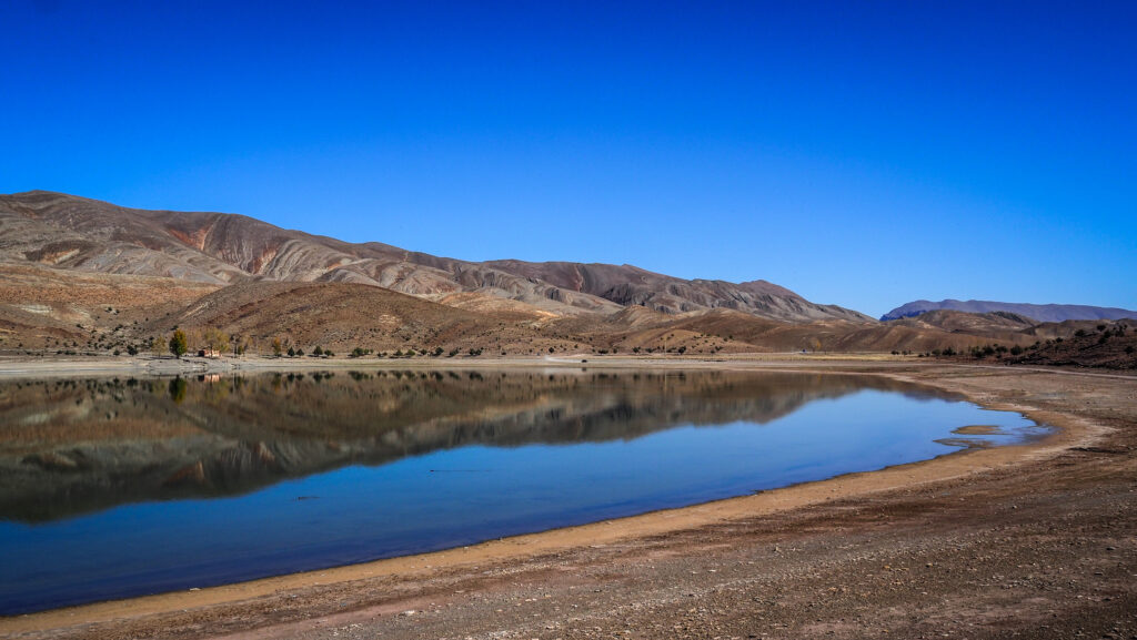
Lake Tislit
How long to stay there?
Half a day is enough to comfortably explore the area of the lakes. There is nothing much to do in the town itself other than having a cup of tea and observing local life going on.
Visiting Lakes Tislit and Isli
Lake Tislit and Lake Isli are situated near the village of Imilchil, at an altitude of over 2,000 meters. The lakes are relatively close to each other (8 kilometres) but are in separate basins, surrounded by rugged mountain terrain. Their high-altitude setting makes the area cold in winter, with snow often covering the surrounding peaks.
The road to Lake Isli
Lake Tislit (often referred to as the “Bride’s Lake”) is smaller and more rounded, while Lake Isli (the “Groom’s Lake”) is larger and more elongated. The lakes are fed by rain and snowmelt from the surrounding mountains, and the area around them is relatively dry, with limited vegetation apart from seasonal grasses and small shrubs.
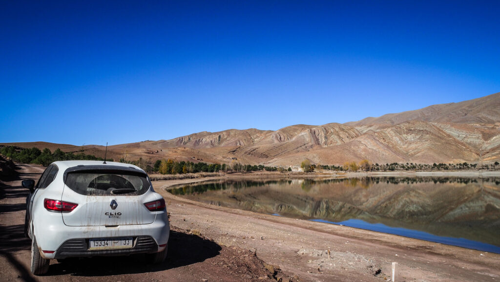
In the beginning, I had no idea that there were actually two lakes. When I reached Lake Tislit, I immediately saw some other dirt road and quickly checked on the map where it was going. Then, I discovered Lake Isli. I wasn’t very sure about road conditions and I was hesitating if driving in Renault Clio was a good idea but I’m happy I took that risk. In dry conditions, the road is quite easy and doable in 2WD. If you are adventurous and looking for a calm place in nature, these are the spots for you!
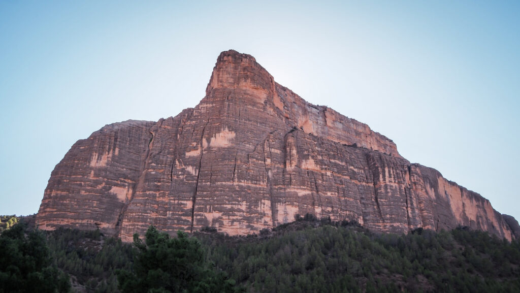
Imsfrane Cathedral has nothing to do with a religious building but it is a striking natural rock formation that rises to 1872 meters above sea level. The term “Cathedral” in this context is used metaphorically to describe the towering and majestic appearance of this rock, which resembles the shape of a cathedral with its steep, vertical cliffs. The rock formation is a popular destination for hikers and nature enthusiasts due to its dramatic geological features.
How to get there?
By Car
From Marrakech, take R210 heading northeast toward Demnate and then continue to Ouaouizeght on R304. It’s going to be about 4 hours drive (216 km). From Ouaouizeght, it’s another 57 km, which takes about 1.5 hours due to the bad condition of the road (doable in a normal car like a Renault Clio).
From Zaouiat Ahansal, take R302 for 43 km. It’s a dirt road so you should count about 1,5 hours to cover that distance.
By Bus/Taxi
You can take a bus from Marrakech to Demnate. Bus companies like CTM operate this route, and the journey takes 2.5 to 3 hours. For further connections, you must ask locals or negotiate the ride with taxi drivers. Be prepared for a long and tiring day.
The best time to visit
Plan your trip in spring or autumn for the best weather conditions. Winter can bring snow and ice to the higher mountain roads, making them difficult to navigate. Summer can be hot, but temperatures are milder in the mountains.
You should always have some warmer layers, regardless of the season. In the end, it’s mountains there!
How long to stay there?
Half a day is enough to get to the top of Imsfrane Cathedral or even do a longer loop. If you want to explore a bit more or at a slower pace, plan one full day.
Where to stay?
If you decide to spend a night in the area, there are some basic options such as Auberge à la Cathedrale Imsfrane or Gîte D’étape La Cathédrale.
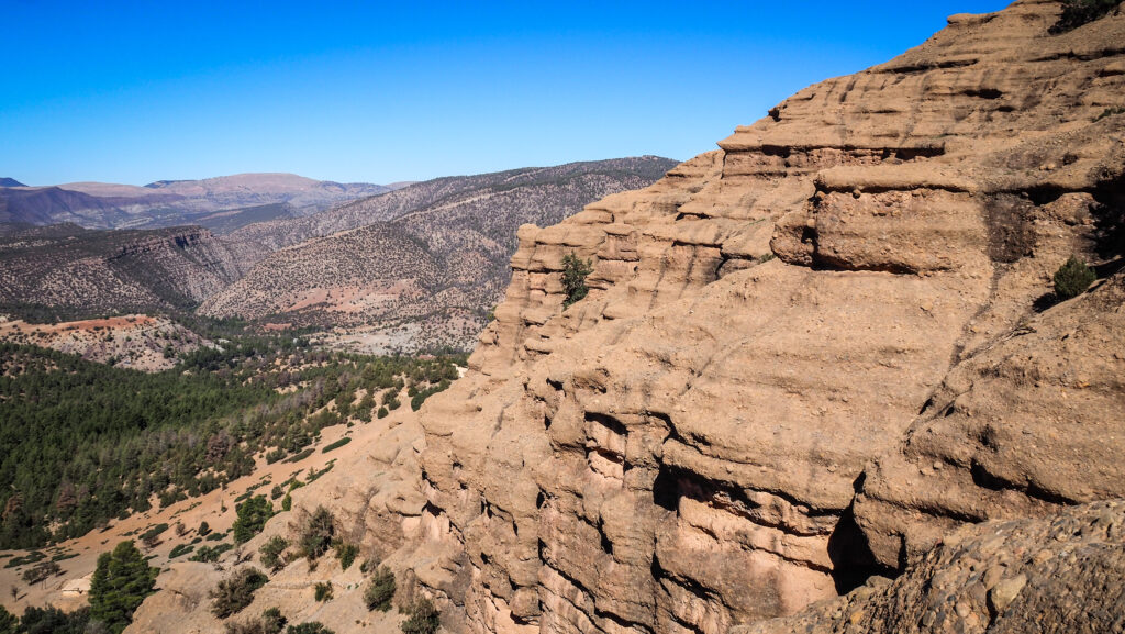
The hike to Imsfrane Cathedral
I left early from Zaouiat Ahansal and had a first good look at the rock from the viewpoint “Vue panoramique sur la cathédrale” just on the roadside. You may find it on Google Maps. It looked truly impressive and I was looking forward to standing on top!
I parked the car just next to Gite La Cathedrale, packed water and hit the trail. I recommend using Mapy.CZ as the trailhead isn’t clearly marked. The plan for that day was to do a loop, including the summit of Imsfrane Cathedral, and returning through Ahansal Gorge. The total distance of 15.2 kilometers.
The mornings in this region can be cold but as soon as I started the ascent, I had to remove some of my layers. It was already getting quite hot, therefore I took off my thermal underwear and continued going up. The trail was obvious and there were also some other people around, so I felt perfectly safe.
First views while going up
The views were nice and soon I passed a group of goats. It’s crazy how they climb these steep rocks. At some point, there was a short small section which was a bit steeper and I thought it was the beginning of a more difficult climb but it wasn’t. The path flattened again and it was steadily climbing on the side of the rock.
Finally, I reached the summit and there was only me and a local vendor. The views were breathtaking! I also felt that I wanted to appreciate the fact that the guy came up all the way to sell hot tea, drinks and snacks so I bought a juice and a pack of walnuts.
At the top of Imsfrane Cathedral
On the way down, I took a different path, on the other side of the mountain. I was descending quickly and this path seemed to be less popular as I met only two other people going in the opposite direction. Once I reached the crossroads, I decided to turn right and head towards the Ahansal Gorge. Unfortunately, it was not exactly what I expected as instead of going down to the canyon, the trail took me to a viewpoint. Well, the view wasn’t bad at all.
The view to Ahansal Gorge
I returned the same way and took another trail heading down to the canyon. Unfortunately, there was another obstacle – a fast fast-flowing stream to cross! I didn’t want to get my shoes wet, nor did I want to cross it barefoot. I somehow managed to move forward on the edge of the rocks but when I thought the worst was behind me, then again I reached the point where crossing the stream was the only solution. I just did it without taking off my shoes. Better safe than sorry!
Imsfrane Cathedral
Soon I joined the main road that I was driving on in the morning. The last meters to the car were quite boring and felt really long. There was absolutely no traffic so I couldn’t catch a ride. I passed by a popular photo spot that I have seen many times on Instagram, with a ruined car.
Finally, I reached my car, bought some chips and tonic in the nearby shop and started driving towards Ouaouizeght. The hike to Imsfrane Cathedral was beautiful and it was a time well spent in nature!
Zaouiat Ahansal is a small, remote village in Morocco’s High Atlas Mountains. It gets its name from the local “zaouia” (religious school or monastery) founded by Sidi Said Ahansal, a revered Islamic scholar and saint.
The village’s religious roots date back to the 16th century when it became a spiritual hub for the surrounding Berber tribes. Sidi Said Ahansal, the founder of the zaouia, established a religious order that drew followers from the High Atlas region. The influence of the Ahansal family extended over centuries, and the local zaouia was both a centre of learning and a point of unity for the local Amazigh (Berber) communities. Today, the religious significance of the village remains a key part of its identity.
Zaouiat Ahansal is set in a dramatic mountainous landscape, surrounded by towering peaks, rugged valleys, and winding rivers, including the Assif Ahansal River. The area is part of Morocco’s central High Atlas range and is known for its pristine nature, making it a popular destination for adventure tourists, climbers, and hikers.
The population of Zaouiat Ahansal is predominantly Amazigh, and the local culture is deeply rooted in traditional Berber customs, language, and ways of life. The Berber people have preserved their unique customs, dialects, and cultural practices for generations in the face of modern challenges. Traditional festivals, clothing, and crafts remain vital parts of everyday life, though they slowly adapt to the contemporary world.
Zaouiat AhansalZaouiat Ahansal
In recent years, Zaouiat Ahansal has become an emerging destination for eco-tourism and adventure travel. Visitors come to explore the untouched natural beauty of the High Atlas, engage in trekking, mountain biking, and rock climbing, or experience the quiet, traditional life of the Amazigh people. Due to its relative isolation, the village has managed to retain much of its authenticity, making it attractive to tourists seeking less commercialized experiences.
When it comes to rock climbing, nearby Taghia Gorge has gained a reputation as one of the premier destinations in the country. The steep limestone walls offer a variety of climbing routes, ranging from technical sport climbs to long, multi-pitch trad routes. Due to the complexity and difficulty of many of the climbs, Taghia attracts serious climbers, including professionals from around the world. The routes vary in difficulty, but many are highly challenging, with climbs often exceeding 300 meters. The gorge is often compared to renowned climbing locations in Europe and has been described as a “paradise” for big-wall climbers. The area was relatively unknown in the global climbing community until the late 20th century when international climbers began exploring the region. The remoteness means that amenities and modern conveniences are limited, adding to the appeal for those looking for an immersive adventure in a natural, undeveloped setting.
How to get there?
Getting to Zaouiat Ahansal, a remote village in the High Atlas Mountains of Morocco, requires some planning due to its isolated location and lack of direct transportation options. However, the journey offers a rewarding experience through Morocco’s rugged mountain landscapes. The most common starting point for travellers heading to Zaouiat Ahansal is Marrakech, the nearest major city with an international airport and well-developed infrastructure. From Marrakech, you have two main options: renting a car or using public transport, though the latter will involve multiple steps.
By Car
Renting a car is the most flexible and efficient way to reach Zaouiat Ahansal, as it gives you control over the journey and allows you to explore the surrounding area at your own pace. The drive from Marrakech takes around 5-7 hours, depending on road conditions and stops.
From Marrakech, head northeast toward the town of Azilal. You’ll follow the R210 road toward Demnate, then take the R304 road, which passes through stunning mountainous terrain. After reaching Azilal, continue toward Ait M’Hamed and head to Zaouiat Ahansal via the rural R302 road. This road becomes narrower and more challenging as you ascend into the High Atlas.
By Public Transport
While public transport options are limited, combining buses and taxis to reach Zaouiat Ahansal is possible, though this will take longer and may require flexibility.
Firstly, take a bus from Marrakech to Azilal. Several bus companies operate this route, and the journey takes about 4-5 hours. Buses to Azilal leave from the main bus station in Marrakech (Gare Routière).
Secondly, find a shared taxi from Azilal to Ait M’Hamed. The grand taxis are often crowded and less comfortable than buses but are commonly used for travel in rural Morocco.
From Ait M’Hamed, there may be local taxis or 4×4 vehicles available to take you to Zaouiat Ahansal, though this can depend on demand. Alternatively, you can hire a guide and arrange a multi-day trek from Ait M’Hamed or another nearby village to reach Zaouiat Ahansal, which can be an adventurous option.
The best time to visit
Plan your trip in spring or autumn for the best weather conditions. Winter can bring snow and ice to the higher mountain roads, making them difficult to navigate. Summer can be hot, but temperatures are milder in the mountains.
You should always have some warmer layers, regardless of the season. In the end, it’s mountains there!
How long to stay there?
One day is enough if you just plan to drive to Taghia Gorge and do some hiking there. You should plan some extra time if you are a climbing enthusiast.
Where to stay?
There are some basic guesthouses in Zaouiat Ahansal, and staying with local families is also an option. I spent the night in AUBERGE Kasbah Ouad Ahanssal. The location is magnificent and so are the views around the property. The shower always had hot water and the dinner was delicious.
What to do in Taghia Gorge?
Passage Berbere
A wonderful place to discover but not for people who are quickly affected by dizziness or are afraid of exposition. It is better to start the adventure in the morning if the weather is mild and the path is dry. Good shoes and a warm layer of clothing are a must. Avoid going there solo in case something goes wrong. Taking a guide might be a smart idea. Otherwise, follow the trail which is visible on Mapy.cz, as shown below. The first section is of medium difficulty and involves some easy scrambling. Then, the proper Passage Berbere is something that I didn’t care to cross. It was made with sticks and stones during the colonization of Morocco so that the Moroccan soldiers could escape the enemy army.
The views around Passage BerberePassage BerbereThe views around Passage Berbere
Drive from Zaouiat Ahansal to Taghia
The dirt road linking these two villages is very narrow so you may have some problems if there is a car coming from the opposite direction. The distance is about 9 kilometers and the views are simply breathtaking with you being surrounded on both sides by the high walls of rock. In good weather conditions, the road is passable in a standard 2WD car (I did it in a Renault Clio). When I was passing through some village en route, there were quite aggressive kids, wanting money and hitting the car windows with their hands. Moments like this make me sceptic about travelling to Morocco but luckily soon happy feelings take over when I see the landscapes. If that happens to you, just keep the door of the car locked and slowly move forward. Do not give those kids any money!
The road between Zaouiat Ahansal and TaghiaThe road between Zaouiat Ahansal and Taghia
Canyon Tazart
On the way back from Taghia, look for some small village with a few houses on your left. It’s a good idea to make a stop there and check out Canyon Tazart. Just follow the dried river bed and double-check your position on Mapy.CZ.
The gorge is completely different from the one around Passage Berbere and walking felt was much safer. At some point, as it was getting late, I decided to turn around and return taking the same path. You should definitely avoid this place in case of rainy weather due to the risk of flash floods.
Canyon TazartCanyon Tazart
Other hikes
There are other hiking opportunities in the area, for one or multiday adventures involving peaks over 3.000 meters above sea level. However, the trails are not marked and it’s highly recommended to hire a guide or at least consult one before setting off.
Tafraoute is a small town in southern Morocco, located in the Anti-Atlas mountains in the Souss-Massa region. Its history is deeply connected to its geography and Berber heritage.
Prehistoric rock carvings and petroglyphs found in the area suggest that early human settlers lived here as far back as the Neolithic period. These carvings depict animals such as gazelles, cattle, and giraffes, showing that the region was once more verdant.
The town is at the heart of a region primarily populated by the Berbers, also known as the Amazigh people, the indigenous inhabitants of North Africa. The Berbers of Tafraoute have a long history of resilience and cultural preservation. Throughout history, they resisted outside rule, including from Phoenician, Roman, and later Arab conquests, maintaining their distinct language, culture, and traditions. Tafraoute is in the territory of the Shilha-speaking Berbers, one of the many Berber language groups in Morocco. Over centuries, the people of this area were known for their semi-nomadic lifestyles, agriculture, and trade across the Sahara.
With the arrival of Islam in the 7th and 8th centuries, Tafraoute, like other parts of Morocco, gradually embraced the new religion. However, the mountainous and isolated nature of the region allowed the local Berber population to maintain a degree of autonomy. During the rule of the Almoravid and Almohad dynasties (11th to 13th centuries), Tafraoute remained part of the broader Moroccan realm, but due to its remote location, it was largely on the periphery of political and military conflicts.
Morocco became a French protectorate in 1912, though the Anti-Atlas region remained difficult for French authorities to control. Tafraoute, with its rugged terrain, was a natural refuge for those resisting colonial rule. The town and its surrounding villages played a role in the Berber resistance movements, especially in the 1920s and 1930s. Berber tribes in this region were fiercely independent, and many revolted against French rule. The colonization of Morocco also brought some infrastructural development to the region, including roads and schools, but the Anti-Atlas remained relatively isolated compared to other parts of the country.
After Morocco gained independence in 1956, Tafraoute became part of the newly unified state. However, it continued to be a relatively isolated and underdeveloped part of the country. In the mid-20th century, many inhabitants of Tafraoute emigrated to urban centres such as Casablanca or abroad, especially to France, for economic opportunities. This has led to a strong Tafraoute diaspora, particularly in Europe. In recent decades, Tafraoute has gained recognition as a tourist destination, known for its stunning landscapes of pink granite mountains, the Ameln Valley, and its traditional Berber culture. Its annual almond blossom festival, held in February or March, celebrates the region’s natural beauty and agricultural heritage.
How to get there?
From Agadir:
By Bus:
Buses, operated by companies like CTM and Supratours, run regularly between Agadir and Tafraoute. This is an affordable and comfortable option, but make sure to check the schedule in advance.
By Grand Taxi:
Shared taxis are available and a faster, but less comfortable, option than the bus. You may have to wait until the taxi fills up with other passengers before departing.
By Rental Car:
Renting a car gives you the most flexibility to explore the beautiful scenery along the way, such as the Anti-Atlas mountains. The drive is scenic but involves winding mountain roads. It’s about 165 km and the drive takes 3 hours.
If you decide to start from Agadir, I recommend using the service of Click’n’Go Car Rental. Amiable guys and easy to contact on WhatsApp. I rented a Renault Clio for the whole month and got a nice price.
From Marrakech:
By Bus:
There are no direct buses from Marrakech to Tafraoute. You’ll need to first take a bus to Agadir (about 3 hours) and then continue from Agadir to Tafraoute by bus or taxi.
By Rental Car:
Driving is the most flexible option. The route takes you through the Anti-Atlas mountains, offering stunning landscapes. The distance is about 380 km and the drive takes about 6 hours.
Landscape around Tafraoute
The best time to visit
The best time to visit Tafraoute is between February and April. This period offers mild and pleasant weather with comfortable daytime temperatures, typically ranging from 18°C to 25°C. This is ideal for outdoor activities such as hiking in the Anti-Atlas mountains, exploring the Ait Mansour Gorge, or wandering through the surrounding valleys. Another highlight of visiting Tafraoute during this time is the Almond Blossom Festival when the almond trees in the Ameln Valley are in full bloom. This creates a stunning spectacle of pink and white blossoms, and the festival itself features traditional Berber music, dance, and local crafts.
Tafraoute, like many parts of southern Morocco, can get extremely hot during the summer months, with temperatures often exceeding 40°C in July and August. The heat can make outdoor activities uncomfortable and limit exploration, so it’s best to avoid visiting during this time.
If spring isn’t an option, September to November is another good time to visit. The weather cools down after the summer heat, and temperatures become more pleasant for hiking and sightseeing.
Landscape around Tafraoute
Where to stay?
I stayed in Azur Tafraout. It is located a bit further from the town centre in a very quiet area near the hills but still within walking distance of restaurants. The room was clean and cosy and breakfast provided in the morning was tasty.
How long to stay there?
You can do both, Tafraoute and the drive through Ait Mansour Gorges in one very long day. If you want to include some longer hikes in the area, then a minimum of two days will be needed.
How to get around?
The best is the have a car but if you like walking, then you will be able to see the places around Tafraoute anyway as they aren’t very far from each other. You could even hike to Painted Rocks, although be careful of the weather and you will be crossing desert-like landscapes which can be extremely hot during the day. Get offline Google Maps for that area or even better Mapy.CZ to make sure you won’t get lost.
What to see in Taroudant?
La Maison Berbère Traditionnelle de Tazka
An exciting place where you can learn a lot about the traditional life of the Berbers and see a traditional house with its furnishings. The owner is very nice, and he willingly talks about the current situation in the local community. He also presented old clay pots, tools and the set-up of the house and shared details about how the children studied, where they slept, how they had hammams in the house, how they managed to keep the room steamy, and how the livestock they kept on the ground floor kept the living room and the kitchen warm.
There is a phone number on the door, so if you don’t see anyone around, just give him a call and wait a bit.
La Maison Berbère Traditionnelle de TazkaThe view from La Maison Berbère Traditionnelle de TazkaThe view from La Maison Berbère Traditionnelle de Tazka
Tafraout Valley
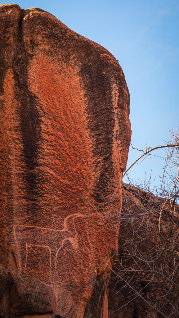
It is a magnificent place with very beautiful rock formations and palm grove walks. Not far from La Maison Berbère Traditionnelle de Tazka, you will find a carved gazelle which is said to be an example of prehistoric rock engravings. I wouldn’t be so sure if it was prehistoric, but anyway, it’s great fun looking for it.
Follow the path further south with the R104 road in the distance on your right. Soon, on the left, you will notice a well-designed path climbing higher up the mountain. At some point, it vanishes but if you do some easy scrambling on the boulders, you will reach a breathtaking viewpoint of the valley.
The viewpoint of Tafraout ValleyThe viewpoint of Tafraout Valley
Mosque Aday
A beautiful mosque that contrasts well with the rocky landscape and is surrounded by old traditional houses.
La Maison Touareg
A popular shop which is full of colours and beautiful items, e.g. rugs, jewellery etc. The owner can get you anything that you need and is a wonderful person who doesn’t push you to buy anything.
Finger Mountains / Napoleon’s Hat
The iconic rock formation is named after its resemblance to the famous Napoleon’s hat. Let’s just say the resemblance is a bit far-fetched.
Napoleon’s Hat
Painted Rocks
Belgian artist Jean Verame created the painted rocks in Tafraoute. The installation lasted three months and required an amazing 18 tonnes of paint.
They are generally known as blue rocks, however they are actually multicoloured. Pink, red, black, yellow, and orange are also present among the blues. Naturally, because the rocks were so exposed, the paint weathered significantly over time. However, they have now been repainted to restore their original vibrancy.
The access road is mostly gravel but suitable for 2WD cars.
Painted RocksPainted Rocks
Ait Mansour Gorges
The Ait Mansour Gorges is a stunning natural feature located near Tafraoute in southern Morocco’s Anti-Atlas mountains. Known for their dramatic rock formations and lush palm groves, the gorges offer a striking contrast between the barren, arid mountains and the greenery of the oasis within them.
Ait Mansour is relatively remote, making it a peaceful and less touristy destination compared to other Moroccan attractions. It is located about 30 km southeast of Tafraoute.
I followed the road R107 and just before the Painted Rocks, I took a left turn towards Ait Mansour. The road was very winding but there was minimal traffic so the driving experience was relaxing. With every kilometre, the views were becoming even more spectacular. The gorges are characterized by towering red and pink granite cliffs that rise dramatically on either side of a winding valley. The landscape is a mix of rocky terrain and lush vegetation, with palm trees, olive groves, and small agricultural plots fed by natural springs.
The winding road is climbing higher and higher
I made a quick stop in Ait Mansour to drink a coffee and have a walk among palms. The oasis is watered by a river that runs through the gorges, providing a life-giving resource to the otherwise dry landscape.
The area around the Ait Mansour Gorges is home to traditional Amazigh (Berber) communities. Small villages are scattered throughout the gorge, where locals live in mud-brick houses and practice subsistence farming.
The oasis in the valley looks amazingDriving through Ait Mansour
From Ait Mansour I continued the drive towards Gdour and then I turned right to continue the loop through Ait Bou Nouh and Ait Ou Said and in the end connecting again with the road R107. It was easily one of the best drives that I have done in Morocco!
The entire loop is about 100 km long and the drive takes 3 hours. Don’t rush it though! You will want to make plenty of stops!
Driving through Ait Mansour GorgesScenic road continuesScenic road continues
Taroudant is a historic town located in southern Morocco, which is believed to have a similar appearance to Marrakesh, though it’s smaller and less hectic. It is set against a stunning backdrop of the Atlas Mountains and surrounded by well-preserved, reddish-brown walls that give it a fortified, medieval feel. Unlike Marrakesh, it’s less touristy, offering a more authentic experience of Moroccan life.
Taroudant’s history stretches back to ancient times, with its origins likely rooted in a Berber settlement. The town gained prominence in the 11th century during the Almoravid dynasty, which used it as a military base due to its strategic location in the Souss Valley. However, it was during the Saadian dynasty in the 16th century that Taroudant truly flourished. The Saadian sultan, Mohammed ash-Sheikh, transformed the town into a key administrative and military centre. He constructed the impressive city walls and fortifications that still stand today, and Taroudant became a thriving hub of trade and culture, benefiting from its position on important caravan routes linking the Sahara to the Atlantic coast. In the centuries that followed, the town experienced periods of decline, particularly after the capital was moved to Marrakesh. However, Taroudant retained its regional importance, especially as a centre for agricultural production, thanks to the fertile lands surrounding it.
How to get there?
By Air:
The closest major airport to Taroudant is Agadir Al Massira Airport (AGA), about 65 kilometres away. You can take a taxi, arrange a private transfer or rent a car from the airport to Taroudant. The drive takes about 1 to 1.5 hours.
By Bus:
Regular buses run from Agadir to Taroudant and are operated by companies like CTM and Supratours. There are also bus services from Marrakech; the journey takes around 4 to 5 hours.
By Car:
The drive from Agadir to Taroudant is straightforward, and scenic, and takes about 1,5 hours (82 km). From Marrakech, the journey is around 3.5 to 4 hours (270 km).
If you decide to start from Agadir, I recommend using the service of Click’n’Go Car Rental. Amiable guys and easy to contact on WhatsApp. I rented a Renault Clio for the whole month and got a nice price.
By Taxi:
In Morocco, shared taxis also known as ‘grand taxis’ operate on longer routes between cities. You can take one from Agadir or Marrakech directly to Taroudant.
By Train:
There is no direct train service to Taroudant. The nearest train stations are in Marrakech or Agadir, after which you’ll need to take a bus, taxi, or car to reach Taroudant.
The best time to visit Taroudant is spring (March to May) and fall (September to November). During these seasons, the weather is pleasantly warm with daytime temperatures typically ranging between 20C and 30C, making it ideal for exploring the town and its surroundings.
Winter (December to February) can also be a good time to visit, as temperatures are cooler, especially in the evenings, but still mild compared to many other destinations.
Summer (June to August) is generally hot, with temperatures often exceeding 35C, which might be uncomfortable for some travellers. However, this is also a low tourist season so you might find fewer crowds and better deals on accommodations.
The streets of Taroudant
Where to stay?
I stayed in Chambres d’Hôtes les Amis. It is located within walking distance of the city walls and if you have a car, you can park it in the narrow street beside the building. The room was clean and cosy and so was the shared bathroom. A good breakfast is served on the rooftop terrace. The only negative point was the weak WIFI signal in the room.
How long to stay there?
One full day is enough to discover the city comfortably and even fit a few hours’ trip out of town to Tiout Kasbah if you feel like it.
Street seller in Taroudant
How to get around?
The medina is inside impressive city walls and can be easily discovered on foot. To get to Tiout Kasbah, you will need a rental car or negotiate a taxi ride.
What to see in Taroudant?
From my accommodation, the first significant sight I approached when heading towards the city centre was Bab Taryunt, the historical west entrance to Taroudant. A few hundred meters further following Boulevard Mohammed V is Place Assarag. It’s a traditional Moroccan square with mall stalls, preachers, restaurants, and horse and carriage rides. It is said to be a mini version of Jemaa el-Fnaa in Marrakech.
Another square worth mentioning is 20 August Place, located just outside the city wall. You can find there a large area with a fountain in the middle. Nearby is Bab El Kasbah, an impressive city gate.
Constructed by Moulay Ismail, the historic Kasbah section is now a poor but safe residential neighbourhood with narrow streets and low arches leading to small squares and dead ends. Kasbah Garden was created by Hotel Palais Salam but it seems not to be maintained anymore.
I went for a stroll in Brahim Roudani Garden and checked out Fontaine Passage Palmeraie. Nice and relaxing spot, but the fountains don’t seem to be working for a while.
All in all, the best that Taroudant has to offer is its walls. Walking along them, admiring magnificent city gates, having a mint tea at one of the cafes and simply observing local life going on will make for a worthy day in town.
Exploring the streets of TaroudantUnfortunately, it was a very rainy dayOne of the city gatesCity wallsMonument in Taroudant20 August Place
What to see around Taroudant?
Tiout Kasbah
Standing atop a hill, this majestic kasbah is a remnant of the Saadian period (16th century). At the base of the Kasbah is the genuine maze-like palm forest. You can stroll among orange, pomegranate, carob, and more than 20,000 palm trees as you follow the irrigation canals. As soon as you arrive, you will be offered guided tours or donkey rides. Some guides are very persistent! There is also a panoramic restaurant serving traditional Berber dishes. The Kasbah is located 30 km from Taroudant on the route to Tata.
Casablanca, now a bustling metropolis in Morocco, has a rich and varied history shaped by various cultures and influences over the centuries. The area around the town has been inhabited since at least the 7th century BC. The Berbers, the indigenous people of North Africa, were among the first to settle here.
The Phoenicians established a trading post in the region, followed by the Romans, who called it Anfa. By the 8th century, Anfa had become an important port for the Berber Kingdom of Barghawata.
In the 15th century, Portuguese traders and pirates frequently targeted Anfa. In 1468, the Portuguese destroyed the town due to its piracy issues.
In 1515, the Portuguese rebuilt the city and named it Casa Branca, meaning “White House.” They maintained control until the early 18th century and abandoned it following an earthquake and continued conflicts.
Sultan Mohammed ben Abdallah, from the Alaouite dynasty, rebuilt the city in the late 18th century, renaming it Dar el-Beida, which translates to “White House” in Arabic.
In 1912, Casablanca became part of the French Protectorate of Morocco. Under the French administration, the city underwent significant modernization and expansion, with new infrastructure, buildings, and a modern port.
After Morocco gained independence from France in 1956, Casablanca emerged as the country’s economic capital. The town also developed into a cultural centre, symbolizing modernity and progress in Morocco. The famous 1942 film “Casablanca,” though not filmed there, further romanticized the city in global popular culture.
Today, Casablanca is Morocco’s largest city and a key financial centre in Africa. It is home to iconic landmarks like the Hassan II Mosque, one of the largest mosques in the world, and the bustling Corniche seaside district. Unfortunately, the city has a bad reputation for being dirty and chaotic and all is true.
How to get there?
By Air:
Book a flight to Mohammed V International Airport (CMN), the primary airport serving Casablanca. Many major airlines offer direct flights from various global cities.
By Train:
If you’re already in Morocco, you can take a train from cities like Marrakech, Rabat, or Fes. Arrive at Casa Voyageurs or Casa Port, the main train station in Casablanca. ONCF, the national railway operator, provides regular and comfortable services.
By Bus:
Several bus companies, such as CTM and Supratours, offer routes to Casablanca from various Moroccan cities. Buses typically arrive at Gare Routière de Casablanca, from where you can take a taxi or local bus to your destination within the city.
By Car:
If you prefer driving, major highways like the A3 and A7 connect Casablanca with other Moroccan cities. You can rent a car from various international and local companies. Ensure you have a valid driver’s license and familiarize yourself with local driving laws.
The best time to visit Casablanca is during the spring (April to June) and autumn (September to November) seasons. The temperatures are mild and pleasant, typically ranging from 15°C to 25°C. It’s a great time to explore the city’s attractions without the peak summer crowds.
During summer (July to August) Casablanca experiences warm weather with temperatures often exceeding 30°C. While it’s not as hot as inland Moroccan cities, the humidity can be high, making it less comfortable for sightseeing.
Winter (December to February) brings cooler weather with temperatures ranging from 8°C to 18°C. While it’s still a viable time to visit, some days may be rainy or windy.
Where to stay?
I stayed in Stayhere Casablanca – Gauthier 1 – Modern Residence which was nicely located near Arab League Park. The room and bathroom were clean but there were constant problems with electricity. The staff were really helpful and were doing their best to sort it out so I believe it won’t be an issue in the future.
How long to stay there?
Two full days are enough to discover the city comfortably and to take a long walk along the corniche. Casablanca is a very dirty and polluted city so you don’t want to stay there too long. Much better places in Morocco are awaiting your visit!
How to get around?
Casablanca has an efficient tramway system that connects different parts of the city. Petit taxis are an option for short distances within the city and grand taxis are for longer routes. Public buses are available too though it might be difficult to figure out the routes and schedules.
What to see in Casablanca?
Day 1
I left for sightseeing very early in the morning and it was nice to see the city waking up. Mohammed V Boulevard is one of the streets in town that has some fine examples of grand colonial-era buildings in Art Deco style, including the famous Cinema Rialto, which was completed in 1929 according to the designs of French architect Pierre Jabin.
After a quick breakfast in the form of croissant with coffee, I took a petit taxi to the biggest attraction in the city: Hassan II Mosque. Its history is deeply intertwined with the vision of King Hassan II, who sought to create a monument reflecting Morocco’s religious and cultural heritage while also making a statement on the global stage. The idea for the mosque was conceived in the 1980s.
The location chosen for the mosque was particularly significant. Perched on a promontory overlooking the Atlantic Ocean, the mosque would symbolize the connection between the heavens and the earth, a theme central to Islamic belief. Construction began in 1986 and was a massive undertaking, employing thousands of workers, artisans, and craftsmen from across Morocco. The project took seven years to complete, with the mosque finally being inaugurated on August 30, 1993, in time for the late king’s birthday celebrations.
The mosque’s construction was a point of national pride, and many Moroccans contributed to its funding through public donations. Architecturally, the Hassan II Mosque is a masterpiece that blends traditional Islamic design with modern engineering. The mosque’s design was the work of the French architect Michel Pinseau, who collaborated closely with Moroccan artisans to ensure that the structure reflected the country’s rich artistic heritage. The mosque features intricate mosaics, carved plaster, and woodwork, all executed with remarkable precision. One of the most striking aspects of the mosque is its minaret, which soars 210 meters into the sky, making it the tallest in the world. This minaret is equipped with a laser beam that points towards Mecca, a reminder of the direction in which Muslims pray.
The glass floor in some sections of the mosque allows worshippers to see the ocean waves beneath them, reinforcing the sense of connection between the earthly and the divine. The mosque is also equipped with modern amenities, including heated floors, retractable roofs, and sophisticated sound systems, ensuring comfort for the worshippers while preserving the sacred ambience. It can accommodate up to 105,000 worshippers, with space for 25,000 inside and 80,000 in the courtyard.
The guided tour lasts about an hour and is mandatory to participate if you want to visit the interior. It includes Prayer Hall, Minaret Hall and Ablution Hall. The cost is 130 MAD for foreigners. Working hours vary so it’s best to check them on the website HERE. Next to the ticket counter is also a small museum where you can kill time waiting for the guided tour to start.
Hassan II MosqueHassan II MosqueHassan II Mosque
From the mosque, you can take a long walk along the corniche towards Observation Deck Al Âank and El Hank Lighthouse. Stunning views of the city and the Atlantic Ocean are guaranteed. The lighthouse is also said to be one of the best places in Casablanca to see the sunset. It came into operation in 1920 and helped the development of the city of Casablanca, as it facilitated access to the port, which was previously considered dangerous. In October 2023 it was not possible to climb it but I have seen reports that it used to be open for tourists so you may want to check it out.
The walk can be continued along Boulevard de l’Océan Atlantique to beaches: Plage Lalla Meryem, Plage Aïn Diab and Plage Madame Choual. Then, take a petit taxi back to the centre of the town: United Nations Square. Constructed at the Medina’s entry during Morocco’s French Protectorate era, it currently serves as a vital hub for the city.
The place used to be occupied by Grand Souk, however, the city continued to expand after the French arrived in the early 20th century, permanently altering areas like this one. Thus, the clock tower was constructed in 1918 and the place was named Square of the Clock (later renamed Square of France). It marked the start of the city’s urban development, led by architect Henri Prost. The Excelsior Hotel and the Paris-Maroc department store are two examples of the new constructions that were erected in the square. The clock tower, which united the old and modern Casablanca, vanished in 1948 and was restored with a replica in 1993.
Nearby, across Rue Felix et Max Guedj is St John’s Church, the first Protestant church to be founded in Casablanca (1906). It was built on land owned by the British Crown and it is the oldest church building in the city.
The Medina Market is not as exciting as the ones in Marrakesh or Fes. This is still a traditional Moroccan medina, worth visiting if you don’t plan to go to other bigger cities, but apart from a couple of shops at its southern side, the neighbourhood is only a collection of somehow rundown residential buildings. Be careful about aggressive selling techniques and people promising to show you the way out. They will just lead you to their friend’s shop and ask for a tip.
Inside the walls of the Medina, there are also some interesting mosques, such as the Great Mosque, and the Ould el-Hamra Mosque (erected under Sultan Muhammad III bin Abdellah in 1789). There are some Jewish temples too. The Ettedgui Synagogue was bombarded by the Allies in November 1942 during the Naval Battle of Casablanca and the reconstruction started in 2011. The Beth-El Synagogue in the Jewish quarter is considered the centrepiece of a once vibrant Jewish community. It can be only visited if you are Jewish.
You might end the day at Rick’s Café, which is a restaurant, bar and cafe, opened in 2004 and designed to recreate the bar made famous by Humphrey Bogart and Ingrid Bergman in the movie classic Casablanca. Despite the title, the movie wasn’t filmed in Morocco but in Hollywood.
Day 2
I kicked off the day with a leisurely early morning walk in Arab League Park. Very well-maintained place with pathways lined with palm trees and neatly manicured bushes and plants. At the centre is a gorgeous fountain. Lots of space for people to stroll, jog, walk their dogs, and for children to play.
Arab League Park
Near the park stands Sacred Heart Cathedral. Actually, it never was a cathedral, as Casablanca is not the seat of a bishopric. There was a sizeable Catholic community in town during the Protectorate times and French architect Paul Tournon designed the church in Art Deco style. Construction began in 1930 and finished in 1953. The country’s Catholic population began to fall three years later, in 1956, when Morocco achieved its independence. As a result, the edifice was no longer used as a church. Most probably you will only see it from the outside as it seems to be permanently closed for renovation.
Another place which is very close to the park is the Villa of Arts. It’s a cultural centre in a 1934 art deco villa, presenting contemporary art exhibitions and events. In my opinion, the building is more interesting than the art itself but of course, it’s a matter of taste 🙂
Mohammed V Square is one of the most lively places in town, especially on the weekends. You will see hundreds of pigeons hanging around (and as a result many objects covered in their shit) and locals feeding them. The square itself is surrounded by some magnificent buildings with traditional designs and rich history: Casablanca Court of First Instance, Poste Maroc and Bank Al-Maghrib.
Other buildings with interesting designs and facades, a bit further away from the square are Café La Princière, Hotel Amouday, Hotel Transatlantique and Hotel Volubilis.
Abderrahman Slaoui Foundation Museum bears the name of a Moroccan businessman and art collector who died in 2001. It showcases an amazing assortment of items, including vintage posters, crystal objects, Moroccan jewellery, Jacques Majorelle’s landscape paintings, Muhammad Ben Ali Rabati’s figurative paintings and much more.
Central Marketplace is an indoor hall built in the early 1900s, known for its selection of seafood. You will be approached by local sellers as soon as you enter it and each of them will do their best to drag you to the restaurant. Be careful as I heard that sometimes unwanted dishes appear on the table (e.g. salad) and the total amount of the bill can increase rapidly. If you notice such a manner, don’t touch the dish and strongly say that they should take it back.
Church of Notre Dame of Lourdes is a modernist Roman Catholic church, about 20 minutes walk from the Arab League Park. It was built in 1954 and the main attraction is the glasswork of world-famous stained glass artist Gabriel Loire.
Further away in the Habbous district, you will the Royal Palace. It’s not open to the public but you can’t see much from the street, other than entrance gates. It is regarded as Morocco’s second most famous royal location after the Royal Palace in Rabat and it has hosted important events. These include Hassan II’s meeting with Pope John Paul II in 1985, the first time a pope visited a Muslim nation at the invitation of an Islamic leader, and the fourth summit of the Organization of Islamic Cooperation in 1984.
Mahkama of Pacha is another interesting building to see in that area but watch out for scams. The place is apparently closed but the guards at the entrance tend to ask for about 100 MAD to let you in but it’s just a bribe and not an official ticket.
If you still have time and energy, visit the Museum of Moroccan Judaism. This institution is housed in a lovely garden home formerly used as a Jewish orphanage. It chronicles the 2000-year history of Jews in Morocco, with a focus on Casablanca’s Jewish community which was the biggest.
It is inconveniently located out of the main tourist zone so the best is the take a taxi to get there. The entrance fee is 50 MAD.
Safi’s history dates back to ancient times, with evidence suggesting it was originally a Phoenician trading post. The Romans also left their mark on the city, known to them as Asfi, which served as a small settlement within the Roman Empire.
With the advent of Islam in the 7th century, Safi became part of the Islamic world. The city flourished under the Idrisid dynasty, establishing it as a significant port. During the 12th century, under the Almohads, Safi became a strategic coastal city and a centre for trade and military operations.
In 1508, the Portuguese captured Safi and fortified it as a stronghold. The Portuguese occupation lasted until 1541 when the Saadian dynasty expelled them. Under the Saadians, Safi became a key trading port, particularly for sugar and other goods. The city also served as a point of contact between Morocco and Europe.
During the Alaouite dynasty, Safi continued to thrive as a port city. The 17th and 18th centuries saw further development and the city expanded its role in regional trade.
Safi grew in prominence as a centre for the ceramic industry, with its pottery becoming renowned throughout Morocco and beyond. The city’s port also became a crucial hub for the export of phosphates, textiles, and other goods.
During the French Protectorate (1912-1956), Safi saw infrastructural development and modernization. The port was expanded, and new industries were established.
After Morocco gained independence in 1956, Safi continued to develop economically and culturally. Today, Safi is known for its rich cultural heritage, particularly its ceramics industry, historic architecture, and vibrant local traditions.
How to get there?
From Casablanca:
By Car:
Take the A3 highway from Casablanca to El Jadida, then continue on the N1 road to Safi. The journey is approximately 250 km and takes around 3-4 hours.
By Bus:
CTM and Supratours offer bus services from Casablanca to Safi. The bus ride takes approximately 4-5 hours.
By Train:
There is no direct train to Safi, but you can take a train from Casablanca to El Jadida, and then a bus or taxi to Safi.
From Marrakech:
By Car:
Take the N8 road to Chichaoua, then the R207 road to Safi. The journey is around 150 km and takes about 2-3 hours.
By Bus:
CTM and Supratours operate buses from Marrakech to Safi. The bus ride typically takes 3-4 hours.
Safi
From Rabat:
By Car:
Take the A1 highway to Casablanca, then follow the same route from Casablanca to Safi. The total distance is approximately 330 km and takes about 4-5 hours.
By Bus:
Take a bus from Rabat to Casablanca and then transfer to a bus heading to Safi.
By Train:
Similar to the route from Casablanca, take a train to El Jadida, then a bus or taxi to Safi.
From Agadir:
By Car:
Take the N1 road north to Safi. The journey is around 230 km and takes about 3-4 hours.
By Bus:
CTM and Supratours provide bus services from Agadir to Safi. The bus ride usually takes around 5-6 hours.
The best time to visit Safi is during the spring (March to May) and fall (September to November) when the weather is mild and pleasant. Summer can be quite hot, while winter brings cooler but still enjoyable temperatures. Choosing spring or fall ensures a comfortable climate for enjoying the beach and exploring the city and its surroundings.
How long to stay there?
You can comfortably spend half a day in Lalla Fatna Beach and another half walking around Safi.
OLYMPUS DIGITAL CAMERAOLYMPUS DIGITAL CAMERA
What to see in Safi?
I reached Safi with shaking legs as the driver of a shared taxi was going over 150 km/h on a single-lane, narrow road along the coast. Insane…
I walked along Corniche de Safi which is a nice little promenade, quite empty during the day but certainly it becomes more alive after sunset. Cleanliness could be improved though. In its northern corner lies Ksar El Bahr, an old fortress which was built at the beginning of the 16th century by the Portuguese. It is now off-limits to tourists due to the damage caused by ocean waves and the lack of maintenance.
Ksar El Bahr
The medina can be accessed by various historical and beautiful city gates: Bab El Maasra, Bab Jdid, Bab Agrour, Bab El Kasbah, Bab Chaaba, and Bab Lakouas. Inside the medina, the best thing that you can do is simply lose yourself in narrow streets, trying to find your way out. I’m sure you will discover many interesting corners and photogenic places.
The streets of SafiThe streets of Safi
You should do your best to locate the Grand Mosque of Safi and the Portuguese Cathedral. The latter is a ruined temple, that was built in 1519 by the Portuguese. The construction was never completed, and most of the structure was demolished after the departure of the Portuguese King Manuel in 1541. All that remains are parts of the choir and a side chapel. As of November 2023, it was not possible to get inside.
The eastern side of the medina is dominated by Dar al-Sultan, also known as the High Kasbah. It is a castle that dates back to the Almohad period and is more than 700 years old. It contains a wall and four towers to monitor any possible external invasion. There is nothing to see inside the building.
Outside of the medina walls is a well-presented and informative National Museum of Ceramics, presenting the history of pottery from different parts of Morocco.
From the National Museum of Ceramics, turn left into Avenue Moulay Idriss 1er to reach the roundabout with the large monument of the tagine, a North African dish, named after the earthenware pot in which it is cooked. It symbolizes the pottery crafts of Safi.
Safi
Lalla Fatna Beach
Lalla Fatna Beach is situated approximately 10 km north of Safi, making it easily accessible for visitors staying in or around the city. The beach is known for its rugged coastline, featuring striking rock formations and cliffs that provide a dramatic backdrop to the sandy shores. The beach is popular among surfers due to its consistent waves and good surfing conditions. There are just basic facilities with one small bar.
You can get a shared taxi to get there from Safi but you will be dropped off at the crossroad and from there, it is about 30 minutes walk down to the beach. On the way back, you will need to hike up to the main road and try your luck with hitchhiking or flagging down a shared taxi. There is no public transport there.
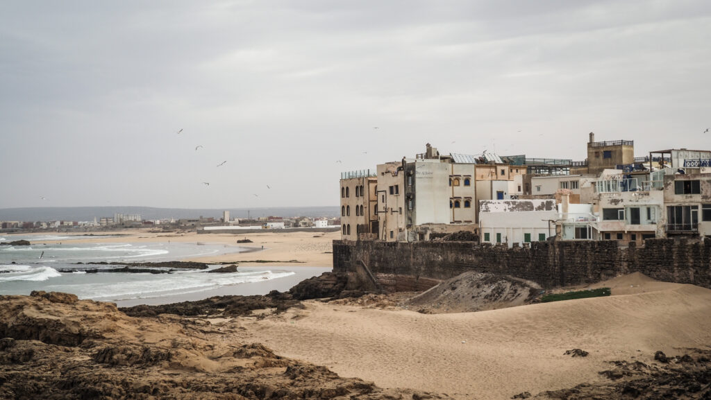
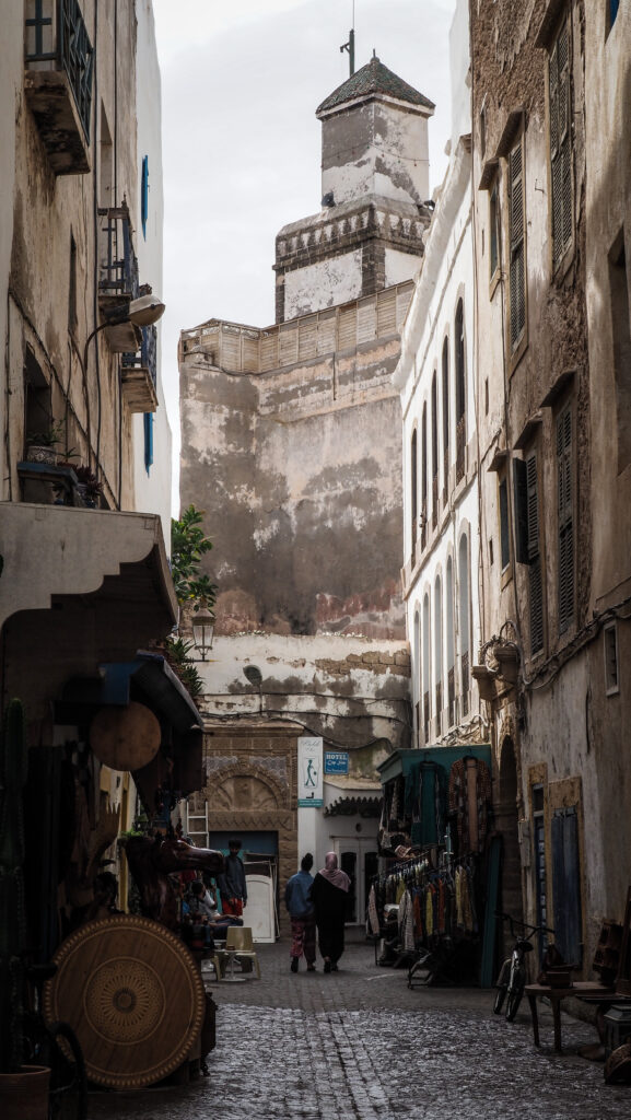
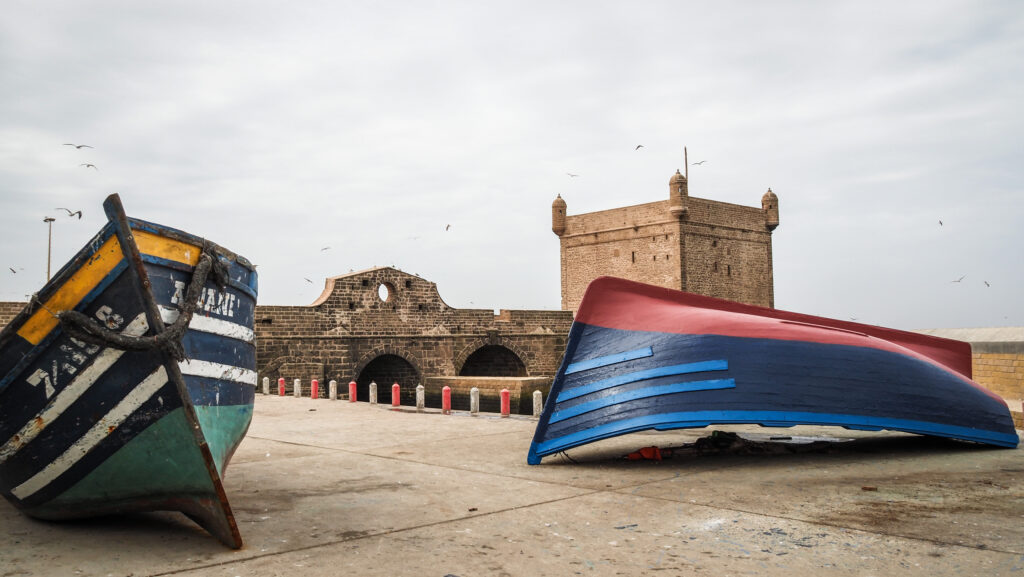
Essaouira, a coastal city in western Morocco, has a rich and diverse history shaped by various civilizations and cultures. Originally known as Mogador, the area has been inhabited since prehistoric times.
The earliest known settlers in the Essaouira region were the Phoenicians, who established a trading post there in the 7th century BCE. The Carthaginians later took control, using the site as an important point for trade with the Berber tribes in the interior.
During the Roman period, the area remained a significant trading hub. Archaeological evidence suggests that Romans traded with the local Berber tribes, exchanging goods such as purple dye made from local murex snails.
In the 7th century, the Islamic conquests reached Morocco, including the region around Essaouira. The area became part of the Islamic world, leading to increased trade and cultural exchange.
During the 11th and 12th centuries, the Almoravid and Almohad dynasties controlled the region. They fortified the area and utilized it as a strategic port, fostering connections across the Islamic world.
In the early 16th century, the Portuguese briefly occupied Mogador, building a fort in 1506. However, they faced strong resistance from local tribes and eventually abandoned the city in 1510.
The Saadian Sultanate in the 16th century used the region for maritime trade. They also built the first true urban settlement at the site, laying the groundwork for its future development.
The modern city of Essaouira was founded in 1764 by Sultan Mohammed ben Abdallah of the Alaouite dynasty. He envisioned it as a major commercial port to strengthen Morocco’s economy. He hired the French architect Théodore Cornut to design the city’s layout, leading to its unique blend of Moroccan and European architectural styles.
Under Sultan Mohammed ben Abdallah, a large Jewish community settled in Essaouira. They played a crucial role in the city’s commercial life, especially in trade between Europe, Africa, and the Middle East. However, by the late 19th century, Essaouira’s significance as a trading port began to wane due to competition from other ports like Casablanca. The decline continued into the early 20th century.
During the French protectorate in Morocco (1912-1956), Essaouira experienced limited development compared to other Moroccan cities. However, it remained an important cultural and fishing centre.
OLYMPUS DIGITAL CAMERA
In recent decades, Essaouira has experienced a cultural revival. The city’s historic medina was designated a UNESCO World Heritage site in 2001. It has become a popular tourist destination known for its vibrant arts scene!
How to get there?
By Air:
Essaouira-Mogador Airport (ESU), located about 17 km from the city, is the closest airport. It has limited international flights, mostly from Europe.
Marrakech Menara Airport (RAK) is a major international airport about 180 km from Essaouira. From Marrakech, you can travel to Essaouira by bus, taxi, or rental car.
By Bus:
CTM or Supratours are two reliable bus companies in Morocco. They offer regular services from major cities like Marrakech, Casablanca, and Agadir to Essaouira. The journey from Marrakech takes around 2.5 to 3 hours.
By Car:
The drive from Marrakesh takes about 2.5 hours. Renting a car gives you flexibility to explore along the way.
From Casablanca, the drive takes about 5 hours.
By Taxi:
There are shared taxis that operate between cities. They are less comfortable than buses but can be faster.
By Train:
There are no direct train services to Essaouira. The nearest train station is in Marrakech, from where you would need to take a bus or taxi.
By Organized Tour:
Many travel agencies in major Moroccan cities offer organized tours to Essaouira. These can be a convenient option if you prefer not to arrange transportation yourself.
The best time to visit the city is during the spring (March to May) and fall (September to November) when the weather is mild and pleasant. Summer can be quite hot, while winter brings cooler but still enjoyable temperatures. Choosing spring or fall ensures a comfortable climate for enjoying the beach and exploring the cities and their surroundings.
Where to stay?
I stayed in Hotel Al Arboussaswhich was perfectly located within the medina. The room and bathroom were clean and everything worked well.
How long to stay there?
One full day is enough to comfortably discover the medina and to take a long walk along the beach.
Essaouira
What to see in Essaouira?
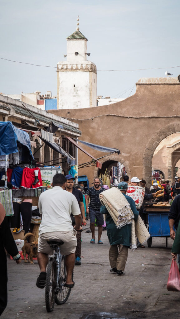
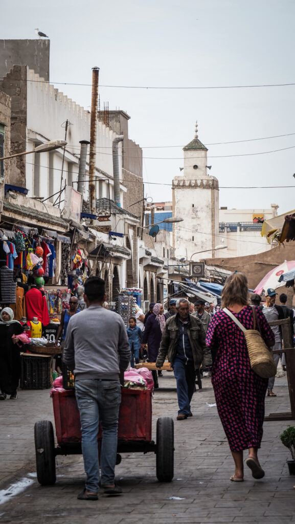
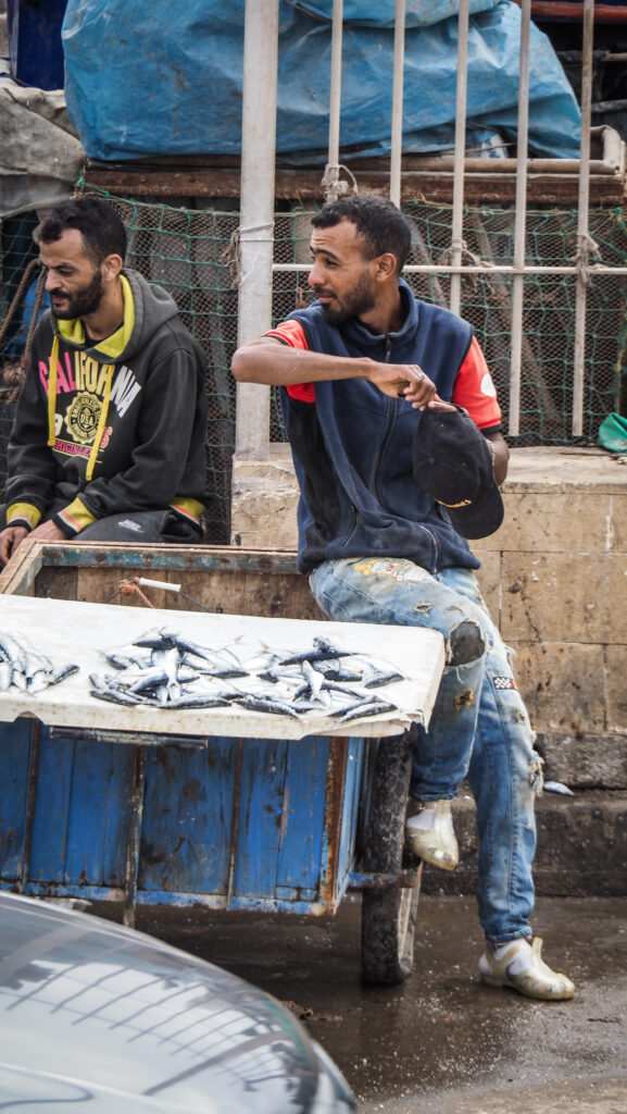
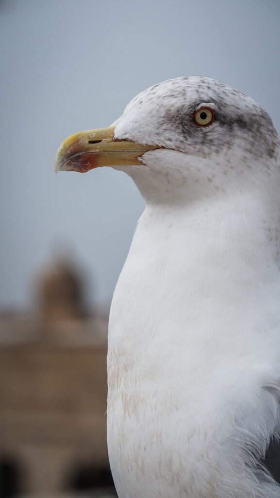
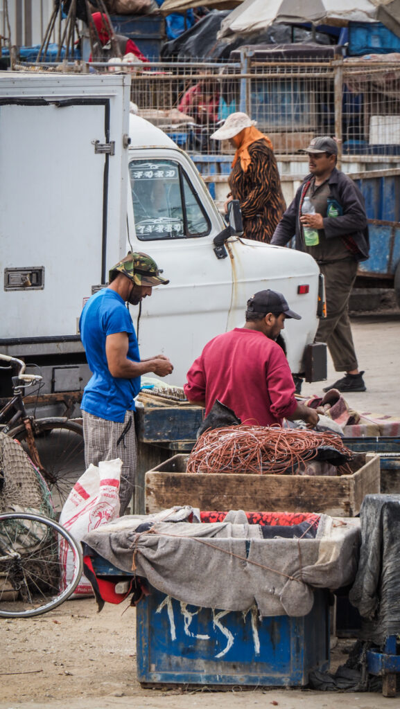
It was a bit cloudy morning in Essaouira but together with the sound of seagulls, it created some special atmosphere. I walked around the centre, passing by lots of lively and enthusiastic street vendors and covered fish market. The smell wasn’t my favourite but damn, it’s an excellent place for photography of people at their work.
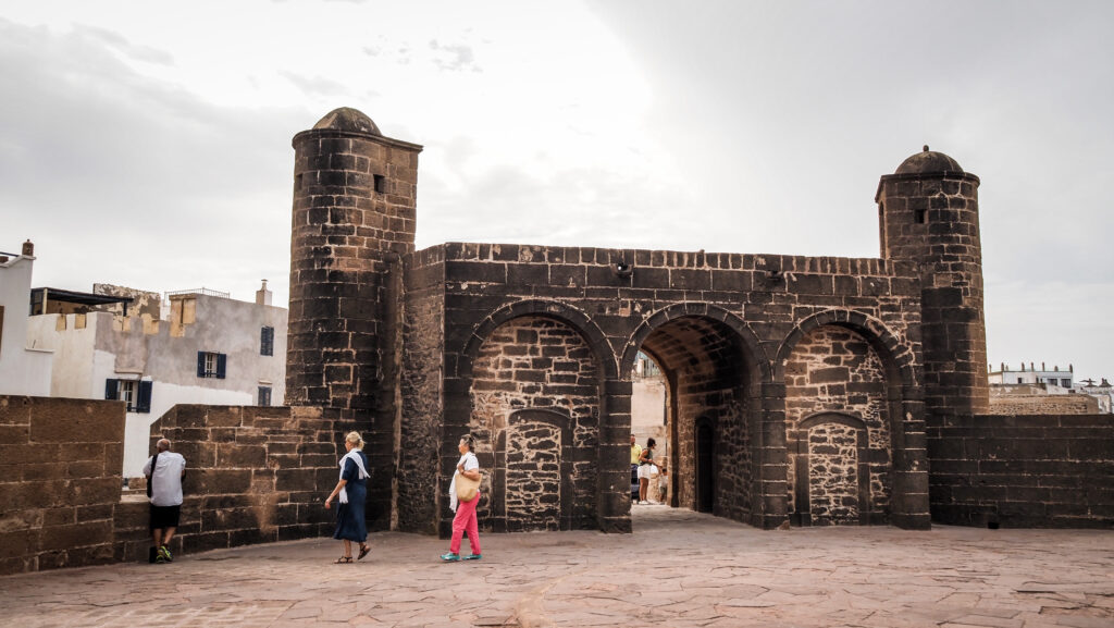
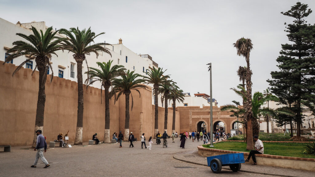
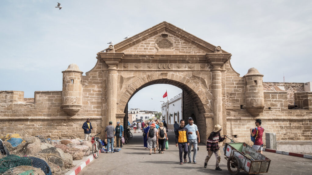
I wandered around narrow streets full of shops selling local handicrafts. It’s one of the best things to do in Essaouira… just walk and get lost. Sooner or later you will anyway reach the city walls or one of the impressive city gates that date from the late 18th century and were added to Unesco’s World Heritage list in 2001.
Haim Pinto Synagogue is one of a few such places that survived from the old times when Jews were present in the city. A Beautiful and tiny place. The downstairs is where the rabbi lived and the synagogue was located upstairs. Very close to it is Synagogue Slat Lkahal Mogador, another impressively restored place. It’s free to visit but you can leave a donation. If it’s closed, call the number visible on the door and the caretaker will come to let you in.
Musée Sidi Mohammed Ben Abdellah, housed in an old riad, features a small collection of local jewellery, costumes, needlework, woodcarving, and weapons.
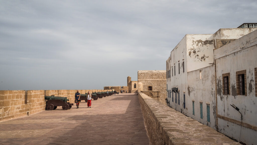
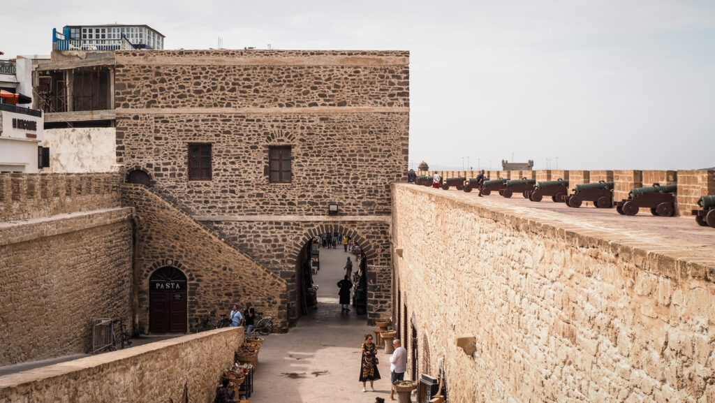
The Portuguese constructed the Old Fortress in the 18th century. It offers a striking perspective of the walls and rooftops of the old medina, and the original canons are still intact. The visitors are welcome to explore them and ascend to see the amazing view.
City walls and cannonsCity walls and cannonsCity walls
Bayt Dakira is the most interesting museum in town. It shows the history of Jewish people in Essaouira and how they interacted with the Muslim community. The visit is free. Nearby Gallery Kasbah is truly an art gallery different from other similar places. With a diverse array of artworks, it’s captivating and makes exploration really exciting. Make sure to visit all the floors, especially the rooftop, which boasts a stunning city view. If you have enough space at home, consider purchasing something from their collection! The visit here is free as well.
Horloge d’Essaouira is a pretty clock tower, easy to find as you go through the gateway of Bab Sbaa. There is a lovely little square with trees, cafes and restaurants. The tower is not open to the public.
Pretty streets lined with palm trees
Bab Sbaa is one of the original and probably the most used city gate today. It is the main entrance if you are coming from the beach or the promenade. The outer area is like a small urban park and also the main pick point for all the local taxis and buses.
Place Moulay Hassan is a big open space with a lot of things happening there throughout the day. There are many gift shops, antique shops, and cafes around. Local musicians and bands come over to entertain crowds.
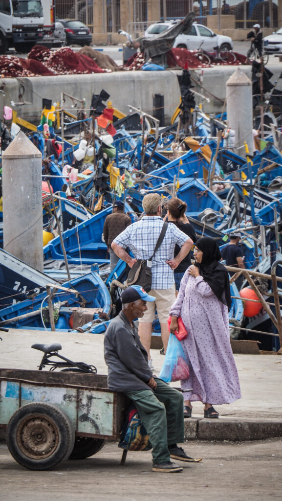
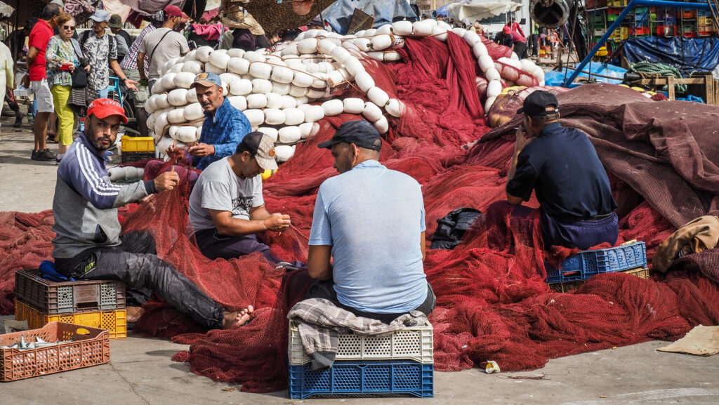
The port of Essaouira is incredibly atmospheric, loud, and stinky. Boats are arriving and departing frequently, unloading day’s catch and local fishermen repair nets. You can also see traditional wooden boats being. It is worth going to the fish auction which is situated right outside the city gate of Bab El Marsa. You can enter nearby fortifications of the bastion for 50 MAD per person. It’s not a huge space and you can walk around it in 10 minutes. The views of the walled medina and Mogador Island are really charming, especially at sunset with many seagulls in the air.
Theportof EssaouiraBab El MarsaA small island off the coastThe bastion
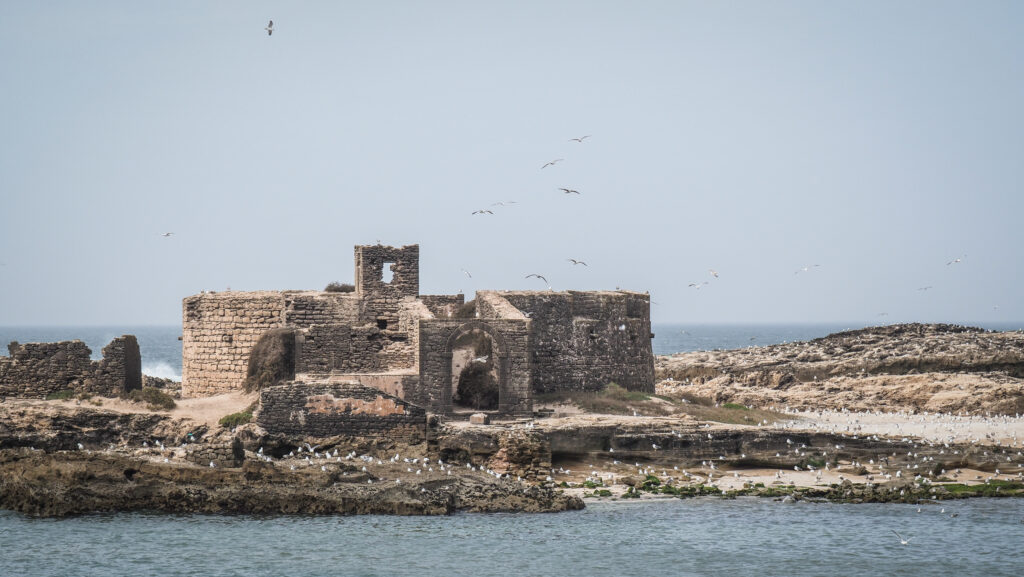
The Carthaginian navigator Hanno visited and established a trading post on Mogador Island in the 5th century BC, and Phoenician artefacts have been found on the island. More recently it served as a woman’s prison and a quarantine centre. Today it is uninhabited and it’s very difficult to secure permits to land there, as it’s a major breeding site for the Eleonora’s falcon. However, you can arrange boat trips around the island.
Plage d’Essaouira and Plage Tagharte are two beaches that run for a few kilometres with some sand dunes at the far end away from the old town. Unfortunately, they are not the cleanest. If you go close to the umbrellas and camels, then you will get accosted by touts. Stay away unless you intend to use their service. If you are up for a challenge, check the offer of surfing / kitesurfing schools.
Azemmour is a historic town located on the Atlantic coast of Morocco, situated about 75 kilometres southwest of Casablanca and near the mouth of the Oum Er-Rbia River. It has a long history, dating back to the Phoenician and Roman periods. It gained prominence during the Islamic period, especially under the Almohad and Merinid dynasties. The town was known for its strategic importance and was a notable centre for trade and commerce.
In the early 16th century, the town was captured by the Portuguese, who built fortifications and left a lasting architectural imprint. They held Azemmour from 1513 until they abandoned it in 1541. That’s why the town features a mix of Moroccan and Portuguese architecture. Notable landmarks include the old medina with its narrow streets and traditional houses, the Portuguese fortress, and the Kasbah, which offers a panoramic view of the Oum Er-Rbia River.
Azzemour
El Jadida is also a coastal city, located about 17 kilometres south of Azzemour. It is the capital of the El Jadida province in the Casablanca-Settat region.
In 1502, the Portuguese established a fortified city called Mazagan on the site. The fortifications were completed in 1541 and included impressive bastions, ramparts, and a cistern, which remains a notable architectural feature. The city served as an important trading post and military stronghold, playing a crucial role in the Portuguese Empire’s presence in Morocco.
In 1769, after more than 250 years of Portuguese control, the city was recaptured by the forces of Sultan Mohammed ben Abdallah of Morocco. The Portuguese, anticipating the siege, destroyed parts of the fortifications before leaving, but the city was soon rebuilt and renamed El Jadida, meaning “The New”.
In 1912, Morocco became a French Protectorate, and El Jadida, like many other Moroccan cities, underwent significant urban development under French influence. The city’s infrastructure improved, and it continued to thrive as a commercial port.
Following Morocco’s independence in 1956, El Jadida continued to grow and modernize. Today, it is a popular tourist destination known for its historical sites, including the Portuguese Cistern and the old fortress, which are part of the UNESCO World Heritage-listed Portuguese City of Mazagan.
How to get there?
From Casablanca:
By Car:
From Casablanca, drive southwest on the A5 motorway. The distance is approximately 75 kilometres and takes about 1 hour. Take the exit toward Azemmour and follow the signs to the town centre.
By Train:
Take a train from Casa Voyageurs or Casablanca Port stations to Azemmour. The journey usually takes around 1 to 1.5 hours. The Moroccan railway operator ONCF runs frequent trains between these destinations. Once at the Azemmour train station, you can take a taxi to reach the town centre or just walk.
By Bus:
Various bus companies operate services from Casablanca to Azemmour. The trip duration is around 1.5 to 2 hours, depending on traffic and the bus company.
From Azzemour to El Jadida:
By Car:
Drive northeast on the N1 road. The distance is about 17 kilometres and takes approximately 20 minutes.
By Train:
Take a local train from El Jadida to Azemmour. The travel time is around 20-30 minutes. Check the ONCF (Office National des Chemins de Fer) website or visit a local train station for updated schedules and ticket prices.
By Bus:
Some buses go along Boulevard Mohammed V in Azzemour and go all the way to El Jadida. Look for bus stops or ask locals for directions.
By Taxi:
Grand taxis (shared taxis) are available and can take you from El Jadida to Azemmour. The ride is short and inexpensive.
The best time to visit both cities is during the spring (March to May) and fall (September to November) when the weather is mild and pleasant. Summer can be quite hot, while winter brings cooler but still enjoyable temperatures. Choosing spring or fall ensures a comfortable climate for enjoying the beach and exploring the cities and their surroundings.
El Jadida
Where to stay?
I decided to stay in Hotel Dar Aboulanwar in El Jadida which is not in the city centre but easily accessible by taxi for a few dirhams. The room and bathroom were super spacious and impeccably clean!
How long to stay there?
If you start early enough, both cities can be visited comfortably in one long day.
What to see in Azzemour?
I actually decided to ignore all the vigorous taxi drivers at the train station and simply walked to the city centre. First, I made a stop at Mohamed V Bridge, to admire the panorama of the city walls and the Oum Er-Rbia River. Well worth it!
Then I proceed to the medina, which is a highlight of the city. Constructed in the 16th century close to the banks of the Er-Rbia, it still has some of its Portuguese heritage, particularly in the elaborate doors. Locals have a long history of being involved in the arts and handicrafts so you may witness them weaving colourful textiles. It was also much fun to discover enormous murals that cover decaying buildings.
At some point, my peaceful exploring was interrupted by some dude who was following me and kept insisting on being my guide. Super annoying but that is how it works in Morocco so you either have to refuse strongly, or agree but negotiate the price beforehand. He did indeed tell me some interesting facts but of course, the whole ‘tour’ was rushed as he wanted to get rid of me as soon as possible.
We strolled around the Grand Mosque, Kasbah Mosque (fr. Mosquée de la Kasbah) and the Shrine of Rabbi Braham Moul Ness, which comprises several rooms, some subterranean, containing artefacts and books in Hebrew. On the corniche, there are some simple places for tea or coffee with views over the river and fortifications. You can also take a boat trip.
I left medina through the gate towards Av. Allal Ben Abdellah. The city walls on that side were quite impressive. I didn’t have any idea how to get to El Jadida so I simply started walking along Boulevard Mohammed V trying to hitchhike but my presence was totally ignored by all drivers. After 15 minutes, some guy approached me and said that there was a bus stop a few hundred meters away and regular buses head to El Jadida from there. Lucky me!
Azzemour
What to see in El Jadida?
I started exploring the town by walking along the Corniche, with El Jadida Beach to the right. A few people were chilling under umbrellas but at this time of the year (October), it was quite empty. There is Mohammed V Park on the other side of the road but unfortunately, there is lots of trash around.
Then, I walked into the remains of the Portuguese Fortress. Notable structures include the Portuguese Cistern, the Church of the Assumption, and the city’s fortified walls. The main entrance is from the side of Av. de Suez and to the left of the main gate you will see the beautiful door which is the entrance to the old mosque.
The Church of the Assumption is an old Portuguese church from the 16th century, currently transformed into a theatre. It’s rarely open so you rather won’t have the chance to peek inside.
City walls in El JadidaCity walls in El JadidaEl Jadida Beach
A bit further is the cistern, which was built beneath the Citadel before it was enlarged into the greater walled fortification in 1541.It’s unclear what the chamber’s initial purpose was. It may have served as a granary, armoury, or barracks, but in 1541 it was documented as being transformed into a cistern. It has served as a filming setting for several films, the most well-known worldwide being Orson Welles’ Othello. As of October 2023, the building was closed for renovation.
Go past the Spanish Chapel and continue to the city walls. It’s free to access and it’s fun to walk around, even though it’s not possible to do the full loop.